Profile banner
Profile picture

Low Orbit Tourist 🌍📷

@loworbittourist.bsky.social

Google Earth is my copilot. Pictures of places I've never been. Hi-res / 4k on tumblr @LowOrbitTourist on Instagram @LowOrbitTourist@pixelfed.fr https://loworbittourist.tumblr.com/

created August 27, 2023

1,312 followers 60 following 162 posts

view profile on Bluesky

Posts

Profile picture Low Orbit Tourist 🌍📷 (@loworbittourist.bsky.social) reposted

Mc Murdo station and Scott station - Antarctica 🌎 : maps.app.goo.gl/eYqgsfSmY1mW... 4K link : i.imgur.com/Y7JFjxX.jpeg

A satellite picture of a polar coastal region with a rugged, snow-covered landmass on the right. Floating ice chunks scatter across the dark swirling water. On the shore, two research bases—one with clustered buildings and another smaller one with green roofing out against the icy terrain.
7/9/2025, 4:20:49 PM | 24 11 | View on Bluesky | view

Profile picture Low Orbit Tourist 🌍📷 (@loworbittourist.bsky.social)

Mc Murdo station and Scott station - Antarctica 🌎 : maps.app.goo.gl/eYqgsfSmY1mW... 4K link : i.imgur.com/Y7JFjxX.jpeg

A satellite picture of a polar coastal region with a rugged, snow-covered landmass on the right. Floating ice chunks scatter across the dark swirling water. On the shore, two research bases—one with clustered buildings and another smaller one with green roofing out against the icy terrain.
7/9/2025, 4:20:49 PM | 24 11 | View on Bluesky | view

Profile picture HydrologyNL (@hydrology.nl) reposted reply parent

Made this two days ago.

image
4/9/2025, 8:27:01 PM | 18 4 | View on Bluesky | view

Profile picture HiRISE BeautifulMars (NASA) (@uahirise.bsky.social) reposted

HiPOD: Layers Blanket a Crater Floor This image shows a layered rock formation within Jiji Crater that has eroded into buttes and stair-like layers. Our image also indicates that much of the formation has eroded away relative to what has remained. More: uahirise.org/hipod/ESP_06... #Mars #NASA

image
5/9/2025, 1:18:23 PM | 60 18 | View on Bluesky | view

Profile picture Jeff Hollett (@jeffontherock.bsky.social) reposted

A beautiful orange rock posy lichen (Rhizoplaca chrysoleuca), from my time in Yellowknife, NT, Canada. #lichen #fungifriends

Photo of a lichen growing flat on the surface of rock. The lichen is oval in shape and cream coloured with orange discs (apothecia) dotted mainly around is outside edge.
1/9/2025, 12:37:40 PM | 359 68 | View on Bluesky | view

Profile picture Low Orbit Tourist 🌍📷 (@loworbittourist.bsky.social) reposted

Masjid al-Haram and Kaaba - Mecca - Saudi Arabia 🌏 : maps.app.goo.gl/YwT3mcWEhwtR... 4K link : imgur.com/a/DiuLxrj

A satellite picture of Masjid al-Haram in Mecca, showing the large mosque complex with multiple minarets, open courtyards, and the Kaaba at its center. Surrounding areas include dense urban buildings and visible construction activity. Same picture but zoomed in on the Kaaba
31/8/2025, 5:36:18 PM | 33 7 | View on Bluesky | view

Profile picture Low Orbit Tourist 🌍📷 (@loworbittourist.bsky.social) reply parent

that's some impressive resolution there, thanks for sharing !

31/8/2025, 8:33:08 PM | 2 0 | View on Bluesky | view

Profile picture Worldview Earth Data 🌍🌱 (@wed-explorer.bsky.social) reposted reply parent

This 30 cm-class image of Mecca🕋, Saudi Arabia. 🛰 maxar.com

image
31/8/2025, 8:22:19 PM | 17 5 | View on Bluesky | view

Profile picture Low Orbit Tourist 🌍📷 (@loworbittourist.bsky.social) reply parent

I honestly don't know much about its purpose but it is the Kaaba, yes

31/8/2025, 8:12:12 PM | 1 0 | View on Bluesky | view

Profile picture Low Orbit Tourist 🌍📷 (@loworbittourist.bsky.social)

Masjid al-Haram and Kaaba - Mecca - Saudi Arabia 🌏 : maps.app.goo.gl/YwT3mcWEhwtR... 4K link : imgur.com/a/DiuLxrj

A satellite picture of Masjid al-Haram in Mecca, showing the large mosque complex with multiple minarets, open courtyards, and the Kaaba at its center. Surrounding areas include dense urban buildings and visible construction activity. Same picture but zoomed in on the Kaaba
31/8/2025, 5:36:18 PM | 33 7 | View on Bluesky | view

Profile picture 🇳 🇺 🇺 🇽 🇮 🇪 (@nuuxie.bsky.social) reposted

gold & blue and a bit of Escher

30/8/2025, 8:42:25 PM | 62 13 | View on Bluesky | view

Profile picture Kevin M. Gill (@kevinmgill.bsky.social) reposted

Storm systems on Jupiter, NASA Juno Perijove 38. flic.kr/p/2mNqMpK

Storms. NASA/JPL-Caltech/SwRI/MSSS/Kevin M. Gill
31/8/2025, 1:51:10 AM | 242 56 | View on Bluesky | view

Profile picture Low Orbit Tourist 🌍📷 (@loworbittourist.bsky.social) reposted

Ethiopia 🌍 : maps.app.goo.gl/PHcDngweff4Q... 4K link : i.imgur.com/JoyEOty.jpeg

A satellite picture of a dry, sparsely vegetated landscape featuring two prominent circular geological formations—one large eroded crater surrounded by farmland, and one smaller volcanic cone—amid patchy agricultural fields in varying shades of brown and beige.
26/8/2025, 5:22:32 PM | 89 22 | View on Bluesky | view

Profile picture Astropierre (@astropierre.com) reposted

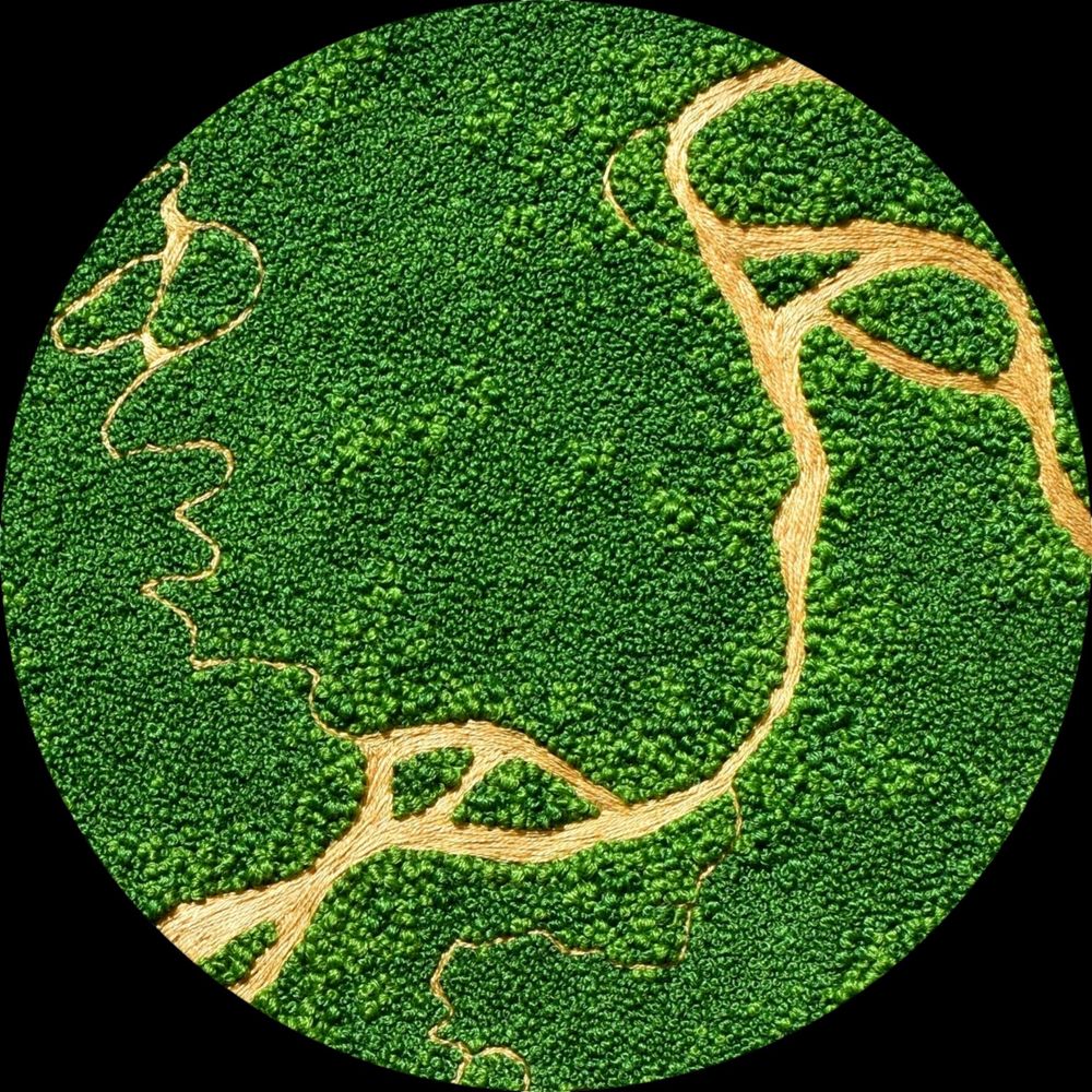
Le satellite européen Biomass, récemment mis en orbite, a observé la Bolivie. Chaque couleur de cette image radar révèle des caractéristiques distinctes du paysage : vert - forêt tropicale rouges - plaines inondables boisées et zones humides, bleu/violet - prairies noir - rivières et lacs 1/2

image
27/8/2025, 8:54:37 AM | 44 7 | View on Bluesky | view

Profile picture Low Orbit Tourist 🌍📷 (@loworbittourist.bsky.social) reply parent

C'est vrai qu'il y a de ça maintenant que tu le dis !

26/8/2025, 6:10:14 PM | 0 0 | View on Bluesky | view

Profile picture Low Orbit Tourist 🌍📷 (@loworbittourist.bsky.social)

Ethiopia 🌍 : maps.app.goo.gl/PHcDngweff4Q... 4K link : i.imgur.com/JoyEOty.jpeg

A satellite picture of a dry, sparsely vegetated landscape featuring two prominent circular geological formations—one large eroded crater surrounded by farmland, and one smaller volcanic cone—amid patchy agricultural fields in varying shades of brown and beige.
26/8/2025, 5:22:32 PM | 89 22 | View on Bluesky | view

Profile picture Low Orbit Tourist 🌍📷 (@loworbittourist.bsky.social) reposted

Irak 🌏 : maps.app.goo.gl/ensg399iQ5gm... 4K link : i.imgur.com/9wpXwgb.jpeg

A satellite picture resembling an intricate network of tree roots or blood vessels, showing a vast, branching river system. The rivers appear as dark green lines that fan out across a beige and brown terrain, highlighting erosion patterns and natural drainage channels.
20/8/2025, 8:22:11 PM | 40 12 | View on Bluesky | view

Profile picture cira-csu.bsky.social (@cira-csu.bsky.social) reposted

A spectacular view of Hurricane Erin swirling north as lightning flashes throughout the system.

21/8/2025, 8:19:42 AM | 109 44 | View on Bluesky | view

Profile picture Dakota Smith (@weatherdak.bsky.social) reposted

Good morning, Erin.

image
20/8/2025, 4:10:53 PM | 35 8 | View on Bluesky | view

Profile picture Low Orbit Tourist 🌍📷 (@loworbittourist.bsky.social)

For reference I already did the same place in 2022 but the satellite picture looked very different back then : loworbittourist.tumblr.com/post/6946791...

21/8/2025, 7:27:10 AM | 8 1 | View on Bluesky | view

Profile picture Low Orbit Tourist 🌍📷 (@loworbittourist.bsky.social)

Irak 🌏 : maps.app.goo.gl/ensg399iQ5gm... 4K link : i.imgur.com/9wpXwgb.jpeg

A satellite picture resembling an intricate network of tree roots or blood vessels, showing a vast, branching river system. The rivers appear as dark green lines that fan out across a beige and brown terrain, highlighting erosion patterns and natural drainage channels.
20/8/2025, 8:22:11 PM | 40 12 | View on Bluesky | view

Profile picture Lila ˚⋆。*˚❀ (@cerosincore.bsky.social) reposted

Regardez mon blog secondaire sur Tumblr où je poste des captures d'écran de choses parfois intéressantes, parfois pas, vues sur Google #streetview (et la description de l'antenne vient de @wikipediafr.bsky.social ) : ▶ www.tumblr.com/streetviewvi...

Une antenne ALLISS au milieu d'un paysage très plat de champs enherbés et cultivés. Le ciel est gris. Je reprends sa description de la page wikipédia sur l'émetteur d'Issoudun, où elle se situe : Une vache noire, seule dans une prairie vert vif, avec derrière elle un grand plan d'eau. Elle a une petite marque blanche sur le front qui ressemble un peu à un coeur. En haut d'une pelouse bien verte, une maison typique du Cantal en pierres apparentes et toit en lauze est construite dans un rocher massif qui fait deux fois sa hauteur.
19/8/2025, 9:33:58 PM | 16 8 | View on Bluesky | view

Profile picture Aaliyah 🇮🇪🇵🇸 ‼️SAVE GAZA‼️ (@aaliyahxx.bsky.social) reposted

TRT captures aerial footage of Israel’s massive destruction in Gaza, showing entire neighborhoods flattened to rubble.

16/8/2025, 4:31:36 AM | 45 42 | View on Bluesky | view

Profile picture Low Orbit Tourist 🌍📷 (@loworbittourist.bsky.social) reposted

Faro - Portugal 🌍 : maps.app.goo.gl/iuNkohBgtBn4... 4K link : i.imgur.com/9LNMQDm.jpeg

A satellite picture of a swampy tidal area with a vibrant blue river with many arms snaking through some brownish marshland.
20/7/2025, 5:08:42 PM | 36 11 | View on Bluesky | view

Profile picture Low Orbit Tourist 🌍📷 (@loworbittourist.bsky.social)

Faro - Portugal 🌍 : maps.app.goo.gl/iuNkohBgtBn4... 4K link : i.imgur.com/9LNMQDm.jpeg

A satellite picture of a swampy tidal area with a vibrant blue river with many arms snaking through some brownish marshland.
20/7/2025, 5:08:42 PM | 36 11 | View on Bluesky | view

Profile picture Low Orbit Tourist 🌍📷 (@loworbittourist.bsky.social) reply parent

my pleasure, thanks for your support !

16/7/2025, 11:01:24 PM | 1 0 | View on Bluesky | view

Profile picture Low Orbit Tourist 🌍📷 (@loworbittourist.bsky.social)

Low Orbit Tourist turned 9 today on Tumblr ! I always miss this anniversary but not this year. Thanks to everyone who follows me here and for the few that are still here from the beginning (I know at least one !) Cheers 🥳

screenshot of the automated tumblr post saying
16/7/2025, 9:15:57 PM | 15 1 | View on Bluesky | view

Profile picture Low Orbit Tourist 🌍📷 (@loworbittourist.bsky.social) reposted

Waw an Namus volcano - Lybia 🌍 : maps.app.goo.gl/o8PFkVp3LyHs... 4K link : i.imgur.com/tDgmPhU.jpeg

A satellite picture of a volcanic structure amidst black sand. The structure is clearer than its surroundings and we can see lakes and a crater in the middle of it.
14/7/2025, 7:08:49 AM | 21 6 | View on Bluesky | view

Profile picture Low Orbit Tourist 🌍📷 (@loworbittourist.bsky.social) reply parent

c'est vrai ça 🦪

14/7/2025, 11:51:05 AM | 0 0 | View on Bluesky | view

Profile picture Low Orbit Tourist 🌍📷 (@loworbittourist.bsky.social)

Waw an Namus volcano - Lybia 🌍 : maps.app.goo.gl/o8PFkVp3LyHs... 4K link : i.imgur.com/tDgmPhU.jpeg

A satellite picture of a volcanic structure amidst black sand. The structure is clearer than its surroundings and we can see lakes and a crater in the middle of it.
14/7/2025, 7:08:49 AM | 21 6 | View on Bluesky | view

Profile picture Low Orbit Tourist 🌍📷 (@loworbittourist.bsky.social) reposted

Lake Abert - Oregon - USA 🌎 : maps.app.goo.gl/ndUru52r9Jio... 4K link : i.imgur.com/br5IN8n.jpeg

A satellite picture of a detail from the shore of a lake showing a dramatic and colorful landscape with swirling patterns of dark blue, white, and rusty red.
9/7/2025, 9:07:20 PM | 23 12 | View on Bluesky | view

Profile picture Low Orbit Tourist 🌍📷 (@loworbittourist.bsky.social)

Lake Abert - Oregon - USA 🌎 : maps.app.goo.gl/ndUru52r9Jio... 4K link : i.imgur.com/br5IN8n.jpeg

A satellite picture of a detail from the shore of a lake showing a dramatic and colorful landscape with swirling patterns of dark blue, white, and rusty red.
9/7/2025, 9:07:20 PM | 23 12 | View on Bluesky | view

Profile picture Paul Byrne (@theplanetaryguy.bsky.social) reposted

Whoa. That's a sprite, an elusive, high-altitude electrical discharge from a thundercloud photographed by NASA astronaut Nichole Ayers from the ISS earlier today. With reported sightings going back more than a century, this phenomenon was first photographed in 1989.

image
3/7/2025, 9:40:14 PM | 6480 2124 | View on Bluesky | view

Profile picture Victoria Rose Richards (@aerialembroidery.bsky.social) reposted reply parent

2/2 and here are some close-ups of the embroidery landscape :) I honestly couldn't tell you how many skeins of green thread went into this commission, I lost track, and all those tiny French knots were hurting my hands after a while... good thing its my favourite knot!! 😆

A close-up of an embroidery landscape of Dunvegan, Canada. East to West is cut through with a blue river, south of it consists of trees and grass and to the north has fields and houses added in. A close-up of an embroidery landscape of Dunvegan, Canada. East to West is cut through with a blue river, south of it consists of trees and grass and to the north has fields and houses added in. A close-up of an embroidery landscape of Dunvegan, Canada. French knots trees, satin stitch fields and houses all above a rich blue river. A bridge cuts across it. Thousands of tiny French knots make up this tree area, interspersed with grass and tiny ponds.
3/7/2025, 2:33:01 PM | 90 9 | View on Bluesky | view

Profile picture Victoria Rose Richards (@aerialembroidery.bsky.social) reposted

'Dunvegan', Alberta, Canada - I can finally share this embroidery landscape commission, quite the most intricate piece I've ever created, and I'm so so proud! To me, it really represents how far I've come since I started in 2019. The hoop is 14-inches across to help visualise it 1/2 #embroidered

An embroidery hoop against a stone slab background. The embroidery hoop contains a sewn aerial landscape depicting the Dunvegan bridge over a river, with the south of the river consisting of a tree and grass landscape and the north having the same mixed in with agricultural fields and houses. A road cuts through the whole landscape and the left side has smaller rivers feeding into the main one.
3/7/2025, 2:25:33 PM | 609 145 | View on Bluesky | view

Profile picture Low Orbit Tourist 🌍📷 (@loworbittourist.bsky.social) reply parent

Everything is real on this account, I just frame things in a way I find visually interesting 😌

28/6/2025, 9:24:39 AM | 1 0 | View on Bluesky | view

Profile picture Low Orbit Tourist 🌍📷 (@loworbittourist.bsky.social) reposted

Beckton Sewage Treatment Works - United Kingdom 🌍 : maps.app.goo.gl/ean7PUaVia8j... 4K link : i.imgur.com/JAzjzC1.jpeg

A satellite picture of a wastewater-treatment plant: dozens of square, grey settling basins fill the left half in a neat grid, while the right half shows rows of dark circular clarifiers set in bright green grass, all connected by straight service roads and walkways.
27/6/2025, 8:38:56 AM | 31 12 | View on Bluesky | view

Profile picture kosmi.bsky.social (@kosmi.bsky.social) reposted

Algal vortex in The Baltic Sea. Image taken by Landsat-8 on July 18, 2018.

image
27/6/2025, 6:26:22 PM | 123 36 | View on Bluesky | view

Profile picture Low Orbit Tourist 🌍📷 (@loworbittourist.bsky.social)

Beckton Sewage Treatment Works - United Kingdom 🌍 : maps.app.goo.gl/ean7PUaVia8j... 4K link : i.imgur.com/JAzjzC1.jpeg

A satellite picture of a wastewater-treatment plant: dozens of square, grey settling basins fill the left half in a neat grid, while the right half shows rows of dark circular clarifiers set in bright green grass, all connected by straight service roads and walkways.
27/6/2025, 8:38:56 AM | 31 12 | View on Bluesky | view

Profile picture Victoria Rose Richards (@aerialembroidery.bsky.social) reposted

An embroidered rainbow tulip aerial from 2023 since it is Pride Month!! Happy Pride and I hope you all take care 💚 I am queer and consider myself non-binary or similar but things like parties and parades scare me, too overwhelming... I hope I can attend one some day though 🏳️‍🌈🎉😊 #landscape

An embroidery hoop containing an embroidered aerial view landscape of tulip fields, all in rainbow colours, with two green squares of grass and trees near the centre.
21/6/2025, 3:06:54 PM | 331 86 | View on Bluesky | view

Profile picture Low Orbit Tourist 🌍📷 (@loworbittourist.bsky.social) reply parent

❤️

18/6/2025, 8:11:56 PM | 2 0 | View on Bluesky | view

Profile picture Agou (@agou.bsky.social) reposted

Je finis mon flood de cartes avec une carte sur la Provence vraiment le fond de carte donnait très moyennement envie, je rajoute les reliefs et là BIM elle est magnifique putain T_T même moi je m'étonnne Imprimée sur du papier Fine Arts 310g et de belle taille (60x94cm) www.finke.fr/products/car...

détail de la carte détail de la carte détail de la carte carte de l'ancienne provence
18/6/2025, 4:17:44 PM | 14 4 | View on Bluesky | view

Profile picture Agou (@agou.bsky.social) reposted

Carte de l'Aveyron, retouchée et retravaillée pour ajouter des reliefs (toujours une impression 2D je le rappelle) Format:50x70 cm www.finke.fr/products/car... #cartes #carte #aveyron

carte de l'aveyron, détail carte de l'aveyron, détail carte de l'aveyron carte de l'aveyron, détail
18/6/2025, 7:38:21 AM | 11 5 | View on Bluesky | view

Profile picture Low Orbit Tourist 🌍📷 (@loworbittourist.bsky.social) reposted

Svellingsflaket conservation area - Norway 🌍 : maps.app.goo.gl/Unwpa3DYjAc7... 4K link : i.imgur.com/VXmE5Oh.jpeg

A satellite picture of scattered rocky islands with patches of greenery, surrounded by deep navy water and vivid turquoise shallows and reefs.
15/6/2025, 10:22:56 PM | 31 10 | View on Bluesky | view

Profile picture Low Orbit Tourist 🌍📷 (@loworbittourist.bsky.social)

Svellingsflaket conservation area - Norway 🌍 : maps.app.goo.gl/Unwpa3DYjAc7... 4K link : i.imgur.com/VXmE5Oh.jpeg

A satellite picture of scattered rocky islands with patches of greenery, surrounded by deep navy water and vivid turquoise shallows and reefs.
15/6/2025, 10:22:56 PM | 31 10 | View on Bluesky | view

Profile picture Low Orbit Tourist 🌍📷 (@loworbittourist.bsky.social) reposted

I noticed that I lost a few followers because of this post and I want to be very clear : Please unfollow me if you don't agree with what it says. This account is not made for genocide apologists.

14/6/2025, 6:52:45 PM | 75 8 | View on Bluesky | view

Profile picture Low Orbit Tourist 🌍📷 (@loworbittourist.bsky.social)

I noticed that I lost a few followers because of this post and I want to be very clear : Please unfollow me if you don't agree with what it says. This account is not made for genocide apologists.

14/6/2025, 6:52:45 PM | 75 8 | View on Bluesky | view

Profile picture Low Orbit Tourist 🌍📷 (@loworbittourist.bsky.social) reposted

Jabalya - Gaza strip - Palestine 🌏 : maps.app.goo.gl/jWYF2tvoHnZZ... 4K link : imgur.com/a/AVdOJNx This one is not for the aesthetics. This one is because this genocide is happening under our eyes and even visible from space. Free Palestine Any genocide apology will get a block. Don't try.

A satellite view looking straight down on a densely packed city where most buildings are shattered or flattened into gray-brown rubble, streets barely discernible amid craters and debris, with only a few intact structures and patches of bare earth breaking up the widespread destruction. A satellite view looking straight down on a densely packed city where most buildings are shattered or flattened into gray-brown rubble, streets barely discernible amid craters and debris, with only a few intact structures and patches of bare earth breaking up the widespread destruction. It is the same plade as the first picture but dezoomed a bit.
13/6/2025, 6:29:38 PM | 65 33 | View on Bluesky | view

Profile picture Low Orbit Tourist 🌍📷 (@loworbittourist.bsky.social)

Jabalya - Gaza strip - Palestine 🌏 : maps.app.goo.gl/jWYF2tvoHnZZ... 4K link : imgur.com/a/AVdOJNx This one is not for the aesthetics. This one is because this genocide is happening under our eyes and even visible from space. Free Palestine Any genocide apology will get a block. Don't try.

A satellite view looking straight down on a densely packed city where most buildings are shattered or flattened into gray-brown rubble, streets barely discernible amid craters and debris, with only a few intact structures and patches of bare earth breaking up the widespread destruction. A satellite view looking straight down on a densely packed city where most buildings are shattered or flattened into gray-brown rubble, streets barely discernible amid craters and debris, with only a few intact structures and patches of bare earth breaking up the widespread destruction. It is the same plade as the first picture but dezoomed a bit.
13/6/2025, 6:29:38 PM | 65 33 | View on Bluesky | view

Profile picture kosmi.bsky.social (@kosmi.bsky.social) reposted

Southern part of Lake Eyre in Australia. Multispectral image taken by Sentinel-2 on May 31, 2025. @satellitesci.bsky.social 😊🎨 bsky.app/profile/kosm...

8/6/2025, 10:37:02 PM | 60 11 | View on Bluesky | view

Profile picture Low Orbit Tourist 🌍📷 (@loworbittourist.bsky.social) reposted

JFE Steel West Japan Works - Fukuyama - Japan 🌏 : maps.app.goo.gl/oDmkNVP9hxJF... 4K link : imgur.com/a/NOlbGlM More info on here : www.gem.wiki/JFE_West_Jap...

A satellite picture of a vast industrial complex: dozens of long, low factory buildings packed tightly in parallel rows, their roofs forming a patchwork of muted browns, rust reds, pale yellows, and greens. Narrow internal roads, parked vehicles, and clusters of pipes and machinery border the rectangle-shaped site. A satellite picture of a tight lattice of long, bright-red factory sheds dominates the frame, with narrow service roads threading between them; along the far right edge sits a thin strip of smaller pastel-coloured industrial roofs. A satellite picture of the same complex, split into thirds: on the left, regimented rows of red and tan workshops; in the middle, a dense tangle of silvery pipes and heavy machinery; on the right, dark parallel stockpiles of coal or ore beside conveyors and a waterfront. A satellite picture of a wedge-shaped industrial peninsula—top lined with red-roofed plants, centre packed with processing units, bottom covered by sprawling black ore yards and piers—separated by water from a smaller dockland zone on the left.
6/6/2025, 11:37:15 AM | 178 52 | View on Bluesky | view

Profile picture Low Orbit Tourist 🌍📷 (@loworbittourist.bsky.social) reply parent

AMD X100070E chipset or something like that

7/6/2025, 11:44:33 PM | 1 0 | View on Bluesky | view

Profile picture Paul Byrne (@theplanetaryguy.bsky.social) reposted

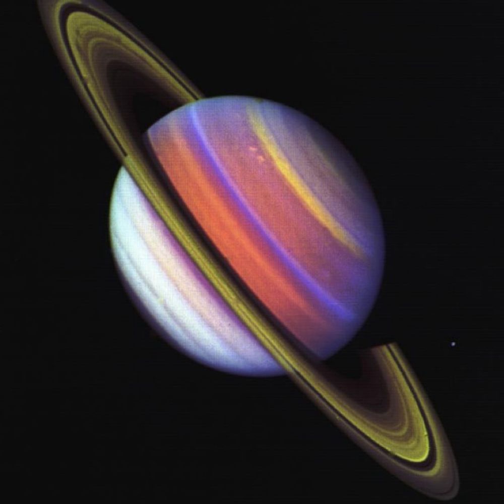
If you need a breather from all this bullshit, here's a photo of Earth. From Saturn. We're that slightly brighter star at centre right.

image
6/6/2025, 1:44:42 AM | 16349 2686 | View on Bluesky | view

Profile picture Low Orbit Tourist 🌍📷 (@loworbittourist.bsky.social)

JFE Steel West Japan Works - Fukuyama - Japan 🌏 : maps.app.goo.gl/oDmkNVP9hxJF... 4K link : imgur.com/a/NOlbGlM More info on here : www.gem.wiki/JFE_West_Jap...

A satellite picture of a vast industrial complex: dozens of long, low factory buildings packed tightly in parallel rows, their roofs forming a patchwork of muted browns, rust reds, pale yellows, and greens. Narrow internal roads, parked vehicles, and clusters of pipes and machinery border the rectangle-shaped site. A satellite picture of a tight lattice of long, bright-red factory sheds dominates the frame, with narrow service roads threading between them; along the far right edge sits a thin strip of smaller pastel-coloured industrial roofs. A satellite picture of the same complex, split into thirds: on the left, regimented rows of red and tan workshops; in the middle, a dense tangle of silvery pipes and heavy machinery; on the right, dark parallel stockpiles of coal or ore beside conveyors and a waterfront. A satellite picture of a wedge-shaped industrial peninsula—top lined with red-roofed plants, centre packed with processing units, bottom covered by sprawling black ore yards and piers—separated by water from a smaller dockland zone on the left.
6/6/2025, 11:37:15 AM | 178 52 | View on Bluesky | view

Profile picture Victoria Rose Richards (@aerialembroidery.bsky.social) reposted

'Finding serenity deep in Ireland' - my finished giant commission, a 16 inch aerial embroidery inspired by the Irish landscape. Soft heathers, segmented fields, and lots of cows and sheep! Complete with a farm house and lake. See the second post in the thread for close-up pictures 💚 1/2

A large embroidery hoop containing a sewn landscape. The landscape is an aerial view of segmented fields and heather-dotted moorland, both separated by a block of trees, The far left shows a blue lake. The fields contain cows and sheep.
4/6/2025, 7:10:17 PM | 639 176 | View on Bluesky | view

Profile picture Andrea Luck (@andrealuck.bsky.social) reposted

Angustus Labyrinthus, known as the "Inca City" near Mars South Pole Full size image 4K: flic.kr/p/2r8Tbk3 Credit: ESA/DLR/FUBerlin/AndreaLuck CC BY ESA Mars Express HRSC 2024-05-02 Filters ND+GR+BL Raw data processed from: psa.esa.int More info: www.dlr.de/en/latest/ne... #planetsci 🧪 @esa.int

A photo of the Martian surface taken by ESA's Mars Express, showing the Angustus Labyrinthus region. The landscape features intricate, intersecting ridges and valleys that resemble the layout of an ancient city, though it is a natural geological formation. The surface is covered in icy material, with circular depressions and smooth areas scattered across the terrain, characteristic of Mars' south pole. The colors are mainly shades of light gray, whitish, with some dark patches, highlighting the region's geological diversity.
4/6/2025, 8:19:02 PM | 129 27 | View on Bluesky | view

Profile picture Low Orbit Tourist 🌍📷 (@loworbittourist.bsky.social) reposted

Argentina 🌎 : maps.app.goo.gl/ZNmzBmtTXu9z... 4K link : i.imgur.com/5ZO6WSb.jpeg

a satellite picture of a grey desertic landscape with a yellow river winding though it from left to right
24/5/2025, 4:35:51 PM | 20 8 | View on Bluesky | view

Profile picture Low Orbit Tourist 🌍📷 (@loworbittourist.bsky.social)

Argentina 🌎 : maps.app.goo.gl/ZNmzBmtTXu9z... 4K link : i.imgur.com/5ZO6WSb.jpeg

a satellite picture of a grey desertic landscape with a yellow river winding though it from left to right
24/5/2025, 4:35:51 PM | 20 8 | View on Bluesky | view

Profile picture Low Orbit Tourist 🌍📷 (@loworbittourist.bsky.social) reposted

QRP with your most popular piece on bsky. Easily this one Gwangyang industrial complex - South Korea 🌏 maps.app.goo.gl/wkR8S3h7z5de... 4K link : i.imgur.com/ytCPbYA.jpeg

20/5/2025, 10:41:48 PM | 50 6 | View on Bluesky | view

Profile picture Low Orbit Tourist 🌍📷 (@loworbittourist.bsky.social) reply parent

and thanks btw :)

20/5/2025, 11:37:11 PM | 2 0 | View on Bluesky | view

Profile picture Low Orbit Tourist 🌍📷 (@loworbittourist.bsky.social) reply parent

oh yes, now I see what you meant !

20/5/2025, 11:31:37 PM | 1 0 | View on Bluesky | view

Profile picture Low Orbit Tourist 🌍📷 (@loworbittourist.bsky.social) reply parent

This is a steelworks plant, not great for the environment but not directly tree-related I'd say

20/5/2025, 11:25:10 PM | 0 0 | View on Bluesky | view

Profile picture Low Orbit Tourist 🌍📷 (@loworbittourist.bsky.social)

QRP with your most popular piece on bsky. Easily this one Gwangyang industrial complex - South Korea 🌏 maps.app.goo.gl/wkR8S3h7z5de... 4K link : i.imgur.com/ytCPbYA.jpeg

20/5/2025, 10:41:48 PM | 50 6 | View on Bluesky | view

Profile picture Kevin M. Gill (@kevinmgill.bsky.social) reposted

Jupiter’s Northern Folded Filamentary Region during Juno’s Perijove 72 earlier this month. There’s a lot going on here so I zoomed into a few highlights. flic.kr/p/2r5VEiy flic.kr/p/2r5VQ8o flic.kr/p/2r5VQ8d flic.kr/p/2r5QmRx

Fisheye view of Jupiter. A multitude of storms and twisted cloud systems. NASA/JPL-Caltech/SwRI/MSSS/Kevin M. Gill A pair of interacting storms. NASA/JPL-Caltech/SwRI/MSSS/Kevin M. Gill A jagged storm with a dark center region. NASA/JPL-Caltech/SwRI/MSSS/Kevin M. Gill A wide storm with dark edges and a light core. NASA/JPL-Caltech/SwRI/MSSS/Kevin M. Gill
20/5/2025, 6:16:50 PM | 186 42 | View on Bluesky | view

Profile picture Low Orbit Tourist 🌍📷 (@loworbittourist.bsky.social) reposted

Mount Saint Helens - Washington - USA 🌎 goo.gl/maps/LDMXp1f... 4K link : i.imgur.com/MnlSJm6.jpg

Mount Saint Helen's crater seen from above
10/9/2023, 9:40:56 PM | 17 8 | View on Bluesky | view

Profile picture Chris Hadfield (@cmdr-hadfield.bsky.social) reposted

From space, watch strong winds blow dust off freshly tilled farmers' fields onto Chicago today. video: @noaa.gov

17/5/2025, 9:01:49 PM | 119 29 | View on Bluesky | view

Profile picture Low Orbit Tourist 🌍📷 (@loworbittourist.bsky.social) reposted

Namibia 🌍https://goo.gl/maps/kdzPUprrEZ2pvJ21A 4K link : i.imgur.com/x0bshKx.jpg

a landscape from above, split between dunes on the left and mountains on the right
29/8/2023, 9:00:56 PM | 14 6 | View on Bluesky | view

Profile picture Low Orbit Tourist 🌍📷 (@loworbittourist.bsky.social) reposted

Fish farms on the Nile delta - Egypt 🌍 maps.app.goo.gl/8ePS2DigztyC... 4K link : i.imgur.com/6i2UZzG.jpeg

a satellite view of fish farms on the coast, forming a stained-glass pattern of deep green on the bottom of the image the top of the frame is vibrant green water swirling around
4/3/2024, 5:08:38 PM | 15 9 | View on Bluesky | view

Profile picture Low Orbit Tourist 🌍📷 (@loworbittourist.bsky.social) reposted

France Miniature theme park - Élancourt - France 🌍 : maps.app.goo.gl/75D9HYojpmHh... 4K link : i.imgur.com/WvakDrs.jpeg

a satellite picture of an urban landscape with a theme park in the shape of France in its middle.
16/5/2025, 9:22:07 AM | 23 10 | View on Bluesky | view

Profile picture Low Orbit Tourist 🌍📷 (@loworbittourist.bsky.social) reply parent

More about France Miniature here, from The Tim Traveler :

16/5/2025, 9:24:22 AM | 2 0 | View on Bluesky | view

Profile picture Low Orbit Tourist 🌍📷 (@loworbittourist.bsky.social)

France Miniature theme park - Élancourt - France 🌍 : maps.app.goo.gl/75D9HYojpmHh... 4K link : i.imgur.com/WvakDrs.jpeg

a satellite picture of an urban landscape with a theme park in the shape of France in its middle.
16/5/2025, 9:22:07 AM | 23 10 | View on Bluesky | view

Profile picture Del - Martian Observer (@martian-observer.art) reposted

NASA Mars Perseverance rover at Jezero, sol 1504 (14th May, 2025) Checking out the results of a new abrasion SHERLOC WATSON Camera Site 73, Drive 1522 📷 Credits: NASA/JPL-Caltech/MSSS/Martian-Observer

Close-up views of the abrasion result. The shallow circular hole hammered out by the tool exposing the true nature of the rock under the ubiquitous Martian dust. The light grey dust and debris from the abrasion stands out clearly. The exposed rock surface appears to contain a lot of black fragments. Similar black fragments can also be seen in the undisturbed surface of the rock, where the blower has cleared the dust. Same view but zoomed in further.
15/5/2025, 10:57:48 PM | 42 6 | View on Bluesky | view

Profile picture kosmi.bsky.social (@kosmi.bsky.social) reposted

Etna volcano in Sicily with recent lava flows. SAR image taken by Sentinel-1 on May 7, 2025.

image
9/5/2025, 8:22:33 PM | 17 2 | View on Bluesky | view

Profile picture aretsch.bsky.social (@aretsch.bsky.social) reposted

Namib today 📸🛰 #Sentinel-3 Footage: @copernicusland.bsky.social

image
6/5/2025, 9:33:51 PM | 9 4 | View on Bluesky | view

Profile picture Low Orbit Tourist 🌍📷 (@loworbittourist.bsky.social) reposted

Seaside resorts in Torre Rinalda - Italy 🌍 : maps.app.goo.gl/E6Nrs2dRuAgD... 4K link : i.imgur.com/NB6hiIM.jpeg

a satellite picture of a seaside resort complex and the sea. th picturee is split in two with the blue sea on the right and the resort + camping on the left
4/5/2025, 8:11:53 PM | 30 9 | View on Bluesky | view

Profile picture Low Orbit Tourist 🌍📷 (@loworbittourist.bsky.social)

Seaside resorts in Torre Rinalda - Italy 🌍 : maps.app.goo.gl/E6Nrs2dRuAgD... 4K link : i.imgur.com/NB6hiIM.jpeg

a satellite picture of a seaside resort complex and the sea. th picturee is split in two with the blue sea on the right and the resort + camping on the left
4/5/2025, 8:11:53 PM | 30 9 | View on Bluesky | view

Profile picture kosmi.bsky.social (@kosmi.bsky.social) reposted

Von Kármán vortex street at the Chirinkotan island. Image taken by Sentinel-2 on April 14, 2025.

image
4/5/2025, 10:02:23 AM | 97 20 | View on Bluesky | view

Profile picture Low Orbit Tourist 🌍📷 (@loworbittourist.bsky.social) reposted

China 🌏 : maps.app.goo.gl/uc3P6u1T1PET... 4K link : i.imgur.com/KJKSbuH.jpeg

a satellite picture of an intensive agricultural landscape with series of grey-blueish greenhouses on light brown soil. the landscape is traversed by a highway
1/5/2025, 7:00:27 PM | 31 7 | View on Bluesky | view

Profile picture aretsch.bsky.social (@aretsch.bsky.social) reposted

One of the last capture in this half of the year by 🛰 Sentinel-3 from the largest global iceberg #A23a (2025.04.30) opposite South Georgia Island. Let's see how big he is when we can see him again next fall with Sentinel-3.

image
1/5/2025, 8:28:06 PM | 8 2 | View on Bluesky | view

Profile picture Robert Simmon (@rsimmon.bsky.social) reposted

Anyone curious about the ground resolving distance of Maxar (maybe Airbus) ultra-high-resolution satellites? Use this calibration target near Batou, China to find out! Screen capture from Google Maps: maps.app.goo.gl/sP7ohqAEHkDU... More info about calibration targets: clui.org/newsletter/w...

Google Maps screen capture of a photo calibration target located at 40.852˚N, 109.629˚E. On the left are four squares about 50 meters across — two white, one gray, and one black. In the upper right are Tri-bar targets that are white stripes that are five times as high as they are wide, with gaps between them equal to their width. The smallest bars with visible gaps between them are 2 meters long — which means the effective ground resolving distance of the satellite that collected the image is about 40 cm.
30/4/2025, 8:11:27 PM | 48 19 | View on Bluesky | view

Profile picture Low Orbit Tourist 🌍📷 (@loworbittourist.bsky.social)

China 🌏 : maps.app.goo.gl/uc3P6u1T1PET... 4K link : i.imgur.com/KJKSbuH.jpeg

a satellite picture of an intensive agricultural landscape with series of grey-blueish greenhouses on light brown soil. the landscape is traversed by a highway
1/5/2025, 7:00:27 PM | 31 7 | View on Bluesky | view

Profile picture Paul Byrne (@theplanetaryguy.bsky.social) reposted

This is a new image from #JWST. The bright points with spikes are stars in the Milky Way. Everything else is a galaxy. Everything. Else. Is. A. Galaxy.

image
29/4/2025, 6:47:17 PM | 18949 4040 | View on Bluesky | view

Profile picture Low Orbit Tourist 🌍📷 (@loworbittourist.bsky.social) reposted

Río Neuquén - Argentina 🌎 : maps.app.goo.gl/7i3oA553tHQ5... 4k link : i.imgur.com/i9jSb6w.jpeg

a river meander seen from above, all around is a desertic landscape in purple and red tones
16/5/2024, 3:48:07 PM | 18 7 | View on Bluesky | view

Profile picture Low Orbit Tourist 🌍📷 (@loworbittourist.bsky.social) reposted

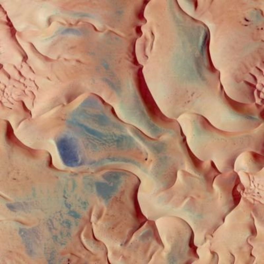
Mongol Els National Park - Mongolia 🌏 : maps.app.goo.gl/AgZZUbMnPqUN... 4K link : i.imgur.com/8l0skbV.jpeg

a satellite picture of desert dunes repeating, looking like sand on a beach but on a much bigger scale
5/9/2024, 9:16:16 PM | 14 5 | View on Bluesky | view

Profile picture Low Orbit Tourist 🌍📷 (@loworbittourist.bsky.social) reposted

HMM PSA New-Port Terminal - Pusan - South Korea 🌏 : maps.app.goo.gl/7zdZNxrLBWoL... 4K link : i.imgur.com/CIApO3B.jpeg

a satellite picture of a big commercial harbor filled with shipping containers and cargo ships. there are lots of automated cranes all around the blue shipping channel taking up all the middle of the frame
27/4/2025, 6:54:28 PM | 47 10 | View on Bluesky | view

Profile picture kosmi.bsky.social (@kosmi.bsky.social) reposted reply parent

[9/44] Two images of Super Typhoon Krathon, warehouse fire in StPetersburg and eruption of Popocatepetl volcano in Mexico.

image image image image
19/11/2024, 4:54:38 PM | 19 5 | View on Bluesky | view

Profile picture Low Orbit Tourist 🌍📷 (@loworbittourist.bsky.social)

HMM PSA New-Port Terminal - Pusan - South Korea 🌏 : maps.app.goo.gl/7zdZNxrLBWoL... 4K link : i.imgur.com/CIApO3B.jpeg

a satellite picture of a big commercial harbor filled with shipping containers and cargo ships. there are lots of automated cranes all around the blue shipping channel taking up all the middle of the frame
27/4/2025, 6:54:28 PM | 47 10 | View on Bluesky | view

Profile picture Landru79 (@landru79.bsky.social) reposted

James #Webb Space Telescope #JWST The Sickle: Pillars of Creation in the Galactic Center Target #SICKLE-MIRI-POS1 Observed: 2024-04-24. Released: 2025-04-24 pi: Cotera, Angela S Inst: #MIRI NASA/ESA/CSA/STScI/j. Roger yuval-harpaz.github.io/astro/jwst_l...

image
24/4/2025, 7:08:48 PM | 119 22 | View on Bluesky | view

Profile picture Astronomy Picture of the Day 🪐 (@apod.shinyakato.dev) reposted

🔭 The Orion Nebula in Visible and Infrared Image Credit & Copyright: Infrared: NASA, Spitzer Space Telescope; Visible: Oliver Czernetz, Siding Spring Obs. apod.nasa.gov/apod/ap25042...

A complex nebula fills the frame that is brightly colored, with red being prominent in the image center and blue being most prominent elsewhere. Stars also dot the image. Please see the explanation for more detailed information.
20/4/2025, 8:00:12 AM | 184 48 | View on Bluesky | view

Profile picture Low Orbit Tourist 🌍📷 (@loworbittourist.bsky.social) reposted

Manicouagan Reservoir - QC - Canada 🌎 : maps.app.goo.gl/pdFuH4Yhp8va... 4K link : i.imgur.com/Z1OKQhO.jpeg Happy Earth day everyone ! thanks a lot to @grostaquin.bsky.social for the location of today's post

a satellite picture of a circular lake amidst a very green landscape. the lake has got a circular island in its middle, making the lake appear as a donut shape
22/4/2025, 7:51:01 PM | 34 12 | View on Bluesky | view

Profile picture Low Orbit Tourist 🌍📷 (@loworbittourist.bsky.social) reply parent

it is a crater originally so that's even more interesting !

22/4/2025, 10:25:21 PM | 1 0 | View on Bluesky | view

Profile picture Low Orbit Tourist 🌍📷 (@loworbittourist.bsky.social) reply parent

Thanks to everyone who shared this post, my account has passed the 1000 followers mark, I'm real glad it happened on this day ☺️

22/4/2025, 9:48:13 PM | 9 0 | View on Bluesky | view

Profile picture Low Orbit Tourist 🌍📷 (@loworbittourist.bsky.social)

Manicouagan Reservoir - QC - Canada 🌎 : maps.app.goo.gl/pdFuH4Yhp8va... 4K link : i.imgur.com/Z1OKQhO.jpeg Happy Earth day everyone ! thanks a lot to @grostaquin.bsky.social for the location of today's post

a satellite picture of a circular lake amidst a very green landscape. the lake has got a circular island in its middle, making the lake appear as a donut shape
22/4/2025, 7:51:01 PM | 34 12 | View on Bluesky | view

Profile picture Low Orbit Tourist 🌍📷 (@loworbittourist.bsky.social) reply parent

damn that's awesome, I wanted to do a post today, looks like, it will be this one :)

22/4/2025, 7:28:10 PM | 1 0 | View on Bluesky | view

Profile picture Low Orbit Tourist 🌍📷 (@loworbittourist.bsky.social) reposted

Reposting this because : #EarthDay

22/4/2025, 11:09:51 AM | 23 10 | View on Bluesky | view

Profile picture Low Orbit Tourist 🌍📷 (@loworbittourist.bsky.social) reposted

Lake Magadi - Kenya 🌍 : maps.app.goo.gl/g8XZ24HSHerz... 4K link : i.imgur.com/YbxC34g.jpeg

a satellite picture of the dried-up surface of a salt lake. the colors range from salmon pink to intense orange turning to black, with a white pattern of cracks all over the surface
21/4/2025, 1:51:18 PM | 16 5 | View on Bluesky | view

Profile picture Low Orbit Tourist 🌍📷 (@loworbittourist.bsky.social)

Reposting this because : #EarthDay

22/4/2025, 11:09:51 AM | 23 10 | View on Bluesky | view

Profile picture Low Orbit Tourist 🌍📷 (@loworbittourist.bsky.social)

Lake Magadi - Kenya 🌍 : maps.app.goo.gl/g8XZ24HSHerz... 4K link : i.imgur.com/YbxC34g.jpeg

a satellite picture of the dried-up surface of a salt lake. the colors range from salmon pink to intense orange turning to black, with a white pattern of cracks all over the surface
21/4/2025, 1:51:18 PM | 16 5 | View on Bluesky | view

Profile picture Hourly Cosmos (@hourlycosmos.bsky.social) reposted

At Devil's Gate - Curiosity, sol 4505 - From Thomas Appéré (thomasappere.bsky.social) - https://flic.kr/p/2qWFWru

Crop version of the previous picture, that is a mosaic of 9 pictures taken by NavCam Right aboard Curiosity rover on sol 4505 (April 8th, 2025) at 7:10 am. Curiosity was parked at Devil's Gate, a small ridgeline between two canyons, where it imaged the view. The hill on the right, called Gould Mesa, is about 30m high. The crater rim is clearly visible in the distance due to the low opacity of the atmosphere at this season. © NASA/JPL-Caltech/MSSS/Thomas Appéré
15/4/2025, 11:00:14 PM | 42 4 | View on Bluesky | view

Profile picture Victoria Rose Richards (@aerialembroidery.bsky.social) reposted

The four aerial embroidery landscapes I still have left available, and the first two are reduced as they've been around quite a while! Which one of the four stands out to you most? :) All here: victoriaroserichards.co.uk/collection/a... and any shares would be very welcome!

An embroidery hoop depicting an aerial landscape. It shows circular paths in an abstract pattern through a vineyard. A large embroidery hoop depicting a 3D aerial landscape. It shows a wide blue river curving through a dense forest with earth paths crossing through the trees and wires overhead. An embroidery hoop depicting an aerial formal garden. Autumn trees and bushes lines criss-crossing paths and blooming plant beds. An embroidery hoop depicting an aerial landscape. It shows rough summer moorland with purple-maroon flowers, dry grass and winding streams past bushy trees.
14/4/2025, 7:22:26 PM | 379 122 | View on Bluesky | view