avatar
Canadian History Ehx @cdnhistoryehx.bsky.social

As the tornado moved over the North Saskatchewan River, it became an F2/F3. It then hit the Clareview area, followed by neighbourhoods in northeast Edmonton. Along with that tornado, another seven tornadoes were reported in the area. 🧵 7/12

The photo is an aerial view of the Sherwood Park Freeway in Edmonton, Alberta, showing heavy traffic congestion on the multi-lane highway post-disaster. Extensive destruction is visible on both sides, including demolished industrial buildings, scattered debris fields, overturned vehicles and heavy equipment, and ravaged grassy areas adjacent to the road.
jul 31, 2025, 12:01 pm • 11 0

Replies

avatar
Canadian History Ehx @cdnhistoryehx.bsky.social

There was one F4, two F2s, an F1 and four F0s. Another F2 touched down south of Edmonton in Millet, as well as one near Vegreville. The Vegreville tornado caused $40,000 in damages and was on the ground for 52 kilometres. 📸 Tom Braid 🧵 8/12

The photo shows three firefighters in yellow helmets and black turnout gear with reflective stripes conducting a search and rescue operation amid a vast field of debris, including splintered wood, twisted metal, insulation, and household items. One firefighter crawls under an overturned dark blue sedan perched sideways on the rubble pile, while another climbs on the car's undercarriage, and a third stands nearby. The background reveals widespread devastation, with flattened structures and trailers extending to the horizon under a cloudy sky.
jul 31, 2025, 12:01 pm • 11 0 • view
avatar
Canadian History Ehx @cdnhistoryehx.bsky.social

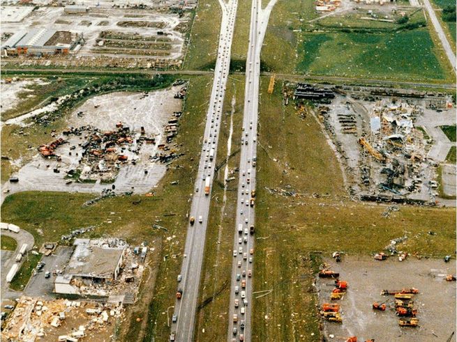
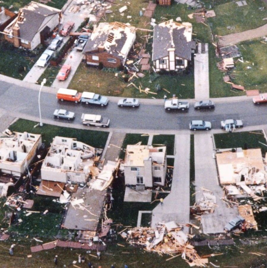
The F4 that hit Edmonton killed 27 people, making it the second-deadliest tornado in Canadian history after the 1912 Regina Cyclone. It injured 300 people and caused over $330 million in damages ($800 million today). The tornado led to major changes in weather reporting. 🧵 9/12

The photo is an aerial view of a suburban residential neighborhood showing varying degrees of tornado damage: several mobile homes and houses at the bottom are completely demolished, reduced to foundations with debris piles of wood, insulation, and rubble scattered across yards; upper houses have roofs partially or fully stripped, with vehicles parked along the curving street and a few people visible amid the wreckage on grassy lots.
jul 31, 2025, 12:01 pm • 12 0 • view
avatar
Canadian History Ehx @cdnhistoryehx.bsky.social

The Emergency Public Warning System, now the Alberta Emergency Alert, was developed after the disaster. The warning system breaks into all broadcasts on radio and television, as well as on cellular phones now. It is also used for Amber Alerts. 🧵 10/12

The photo is a simplified map of Edmonton, Alberta, and environs, depicting the path of the 1987 tornado as a thick black line traversing from southwest to northeast. The track begins near Mill Woods (labeled F2), curves through the city along the North Saskatchewan River (shown in blue), intensifies to F4 near Sherwood Park, then proceeds to F2 near the city center (point O), F2 at point C, F2/F3 at point P, and ends near Evergreen with F2/F3. Major highways like 2, 216, 16, 16A, 14, 15, 21, and 28 are marked in orange and yellow, with suburban areas shaded in beige.
jul 31, 2025, 12:01 pm • 10 0 • view
avatar
Canadian History Ehx @cdnhistoryehx.bsky.social

In 1987, there were only three Doppler radars in operation in Canada, including one near Edmonton. The disaster led to the wide adoption of Doppler radars in Canada. Learn more in my Deep Dive 👇 canadaehx.com/2023/07/25/t... 🧵 11/12

jul 31, 2025, 12:01 pm • 13 1 • view
avatar
Canadian History Ehx @cdnhistoryehx.bsky.social

I hope you found that look at the Edmonton Tornado interesting. If you enjoy my Canadian history content, you can support my work with a donation at 👇 www.buymeacoffee.com/craigu *sources in next post* 🧵 12/12

jul 31, 2025, 12:01 pm • 8 1 • view
avatar
Canadian History Ehx @cdnhistoryehx.bsky.social

Sources: Canadian Encyclopedia: buff.ly/P4f4vUu Canadian Red Cross: buff.ly/50977b3 Reader's Digest Canada: buff.ly/5HE4rLP Daily Hive Vancouver: buff.ly/IvywRic

image
jul 31, 2025, 12:01 pm • 7 0 • view
avatar
brickbq.bsky.social @brickbq.bsky.social

Project 25 ... get rid of 25% of traffic lights in Edmonton. Take a look at Palm Springs .. shopping center traffic is directed to one exit. And I love the playground speed limits ... when Children are Present.

aug 3, 2025, 4:43 am • 0 0 • view