avatar
Canadian History Ehx @cdnhistoryehx.bsky.social

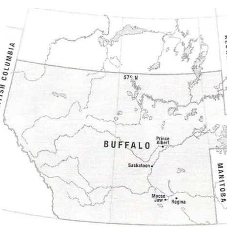
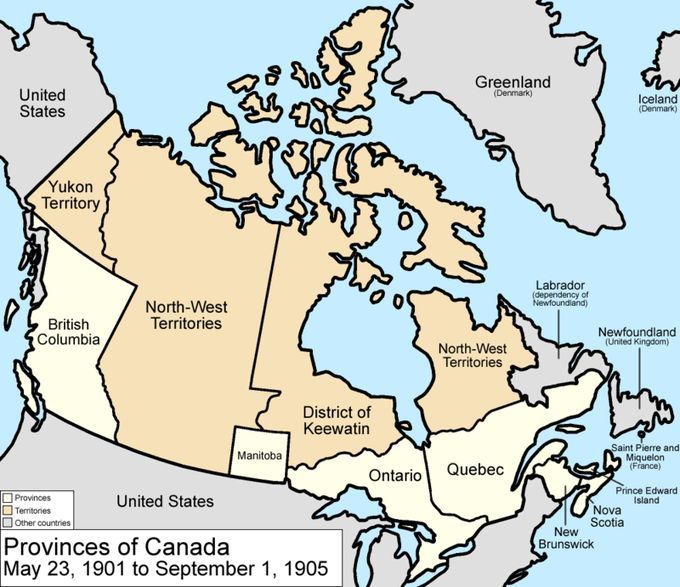
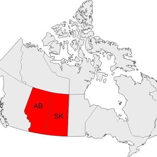
On Sept. 1, 1905, Alberta and Saskatchewan were carved out of the Northwest Territories. But before that happened, there were many possible provincial proposals. One was a very large province called Buffalo. This is the story of the potential provinces! 🧵 1/10

A map highlighting a region in Canada, including parts of British Columbia, Alberta, Saskatchewan, Manitoba, and the North-West Territories. Key cities marked are Edmonton, Calgary, Lethbridge, Medicine Hat, Moose Jaw, Regina, Saskatoon, Prince Albert, Battleford, Wetaskiwin, and Buffalo. The map also shows the 57°N latitude line and includes labels for geographical features and borders, with
sep 1, 2025, 2:03 pm • 111 26

Replies

avatar
simongood.bsky.social @simongood.bsky.social

Not Bison? lol.

sep 1, 2025, 5:12 pm • 1 0 • view
avatar
Canadian History Ehx @cdnhistoryehx.bsky.social

As plans were put into place to create provinces out of the Canadian West as the population increased due to settlers arriving, several proposals were considered. One was to create a single province out of modern-day southern Alberta and Saskatchewan. 🧵2/10

A map showing a section of Canada, including parts of British Columbia, Province One, and Manitoba, with the Thirty-Second Correction Line and the 106°W Meridian marked. The 60°N latitude line is indicated near the top, and
sep 1, 2025, 2:03 pm • 16 1 • view
avatar
Canadian History Ehx @cdnhistoryehx.bsky.social

Another option was to create two provinces, divided west to east, not north to south, at the 52 degrees North. Or create three provinces, one large one stretching from BC to Manitoba in the south, and two in the north, running south from the edge. 🧵3/10

A map depicting a region in Canada divided into three provinces labeled
sep 1, 2025, 2:03 pm • 16 0 • view
avatar
Canadian History Ehx @cdnhistoryehx.bsky.social

Some wanted four provinces, dividing current Alberta in half west to east & making central and southern Saskatchewan into their own provinces. Others wanted 4 provinces, dividing current Alberta in the middle west to east, & then dividing southern Saskatchewan. 🧵4/10

A map showing a region in Canada divided into four provinces labeled
sep 1, 2025, 2:03 pm • 16 0 • view
avatar
Canadian History Ehx @cdnhistoryehx.bsky.social

Then there was the Province of Buffalo. This province encompassed most of present-day Alberta and Saskatchewan, with the border in the northern part of present-day Saskatchewan and running south. Edmonton, Calgary, Saskatoon and Regina were all in one province. 🧵5/10

A map of a region in Canada, highlighting an area labeled
sep 1, 2025, 2:03 pm • 16 0 • view
avatar
Sisyphus with a Hat @sisyphushat.bsky.social

Eish, happy that didnt happen!

sep 1, 2025, 10:37 pm • 0 0 • view
avatar
Canadian History Ehx @cdnhistoryehx.bsky.social

Another version of the province ran from the Rockies to northern Lake Winnipeg, with the northern border at 57 degrees North. Edmonton and Calgary were not in favour of this idea since Regina would be the capital of the large province. 🧵6/10

A historical map of Canada from May 23, 1901, to September 1, 1905, showing the provinces and territories during that period. The provinces include British Columbia, Manitoba, Ontario, Quebec, Nova Scotia, New Brunswick, Prince Edward Island, and Newfoundland (United Kingdom). The territories include Yukon Territory, North-West Territories, and District of Keewatin. The map also marks neighboring regions such as the United States to the south, Greenland (Denmark) to the northeast, Labrador (dependency of Newfoundland) to the east, and Saint Pierre and Miquelon (France) to the southeast. The map uses different colors to distinguish provinces (white) and territories (beige), with other countries shaded in gray.
sep 1, 2025, 2:03 pm • 16 0 • view
avatar
Canadian History Ehx @cdnhistoryehx.bsky.social

NWT Premier Frederick Haultain wanted a large province. But he was a Conservative, and PM Sir Wilfrid Laurier was a Liberal. They did not get along. There was also a concern that a large province in the west would minimize the power of Ontario and Quebec in the east. 🧵7/10

A formal portrait of a man with gray hair and a mustache, dressed in a black tuxedo with a white dress shirt and black bow tie. He is holding a cigarette in his right hand, and the background is a dark, painted setting. The painting is signed with
sep 1, 2025, 2:03 pm • 18 0 • view
avatar
Canadian History Ehx @cdnhistoryehx.bsky.social

Choosing the arbitrary line that is now the Alberta-Saskatchewan border was also to divide the potential strength of the Conservative Party which was concentrated in the south along the CPR mainline in the two provinces. 🧵8/10

A map of Canada with the provinces of Alberta (AB) and Saskatchewan (SK) highlighted in red, located in the western central part of the country. The rest of the provinces and territories are shown in gray, with no other regions highlighted.
sep 1, 2025, 2:03 pm • 17 0 • view
avatar
Canadian History Ehx @cdnhistoryehx.bsky.social

Things could have been different if the Conservatives won the 1904 federal election, and not the Liberals. Had that happened, Manitoba may have seen its border expand westward, not northward, and the remaining area would have become the Province of Buffalo. 🧵9/10

Three flags flying against a clear blue sky with scattered clouds. The top flag is the Alberta provincial flag, featuring a blue background with the provincial shield. The middle flag is the national flag of Canada, with a red and white design and a maple leaf in the center. The bottom flag is the Saskatchewan provincial flag, displaying green and yellow vertical stripes with the provincial shield and a western red lily. The flags are mounted on separate poles.
sep 1, 2025, 2:03 pm • 24 0 • view
avatar
Donald Simmons @donaldfsimmons.bsky.social

We should have just named them Province One and Province Two.

sep 1, 2025, 2:13 pm • 1 0 • view
avatar
Canadian History Ehx @cdnhistoryehx.bsky.social

I hope you enjoyed that look at the Province of Buffalo. If you enjoy my Canadian history content, you can support my work with a donation at 👇 buymeacoffee.com/craigu 🧵10/10

sep 1, 2025, 2:03 pm • 14 1 • view
avatar
Sara Smile @srasmle75.bsky.social

Is that how Buffalo, NY got its name?

sep 1, 2025, 2:07 pm • 1 0 • view