
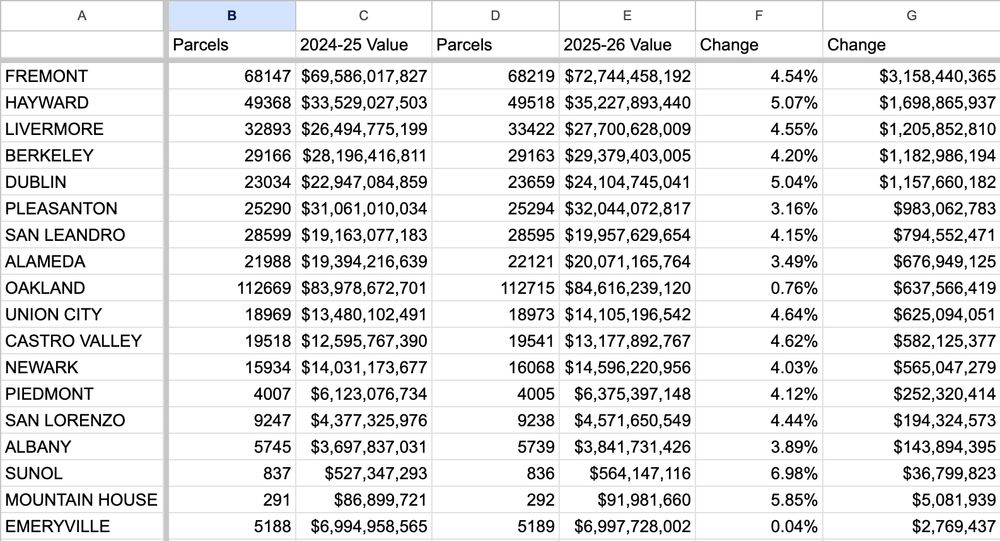
Assessor's rolls were finalized July 1. Just adding up all the net assessed values by place in Alameda County, here are the changes from last year. The big losers with sub-inflation changes seem to be Oakland and Emeryville.
Assessor's rolls were finalized July 1. Just adding up all the net assessed values by place in Alameda County, here are the changes from last year. The big losers with sub-inflation changes seem to be Oakland and Emeryville.
Note that the Assessor produces an official report eventually, and the numbers won't be these, but the percent changes should be close.

I'm taking offense to including Mountain House on this
Is it even in this county? I deleted the silly line item that was coded Tracy, with the corner of one parcel that sticks out over the county line.
Yeah, it's pretty much right along the border of San Joaquin and Alameda on the SJ side. Plus it's like 20 miles out east from Livermore lol
This parcel is quite possibly the single biggest blow to the "if you're in the 9 counties touching the Bay, you're considered part of the Bay Area" argument
Standing at the triple intersection of Merced, Stanislaus, and Santa Clara counties already casts substantial doubts on that definition, in my experience.
