
I think many people fail to truly understand how much land the US has. Mrs. Wolfshade and I took the Amtrak from Chicago to Seattle one year. It's a 46 hr train ride.
I think many people fail to truly understand how much land the US has. Mrs. Wolfshade and I took the Amtrak from Chicago to Seattle one year. It's a 46 hr train ride.

My mother refused to fly so my parents visited us twice. CA to NY = 3 days. It was exhausting for old folks, and expensive as hell because they went 1st class sleeper car (because again, old folks, 3 days, it was a necessity.) But they did get to see America.

I’m going to the Bay Area next week. I’ve a late flight and overnight stay to avoid a 4am start. I’d love to take a sleeper. It’s 700 miles. That shouldn’t be a 20 hour journey.
That one is a smidge far for a train but it should be sub 15 hours even by mid 20th century high speed rail. By late 20/early 21 that should be 10-12 ish not 46 hours. 46 hours is 40mph average! Thats early 20th century rail.
Yeah, it should. 😔

from south Florida, it takes 8 hours just to get the georgia border, and thats in a car. a train is 10 hours and it only gets you to jacksonville. you're still looking at a ~40min drive to the border

That is 2000 miles. 2206 asm.transitdocs and about 40 stops in between.

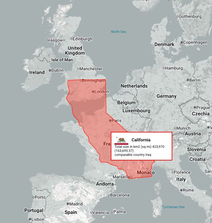
thetruesize.com is super fun to visualize things like this. Here's an image of California superimposed over France for example:
And shockingly you can get the length of that distance by reasonably fast rail. Especially once through the tunnel.

Your post got me wondering about the comparative size of the USA vs Australia. The mainland USA is larger but I was surprised how close the east to west coast distance was.


Woah Tasmania is big!
That's a cool visualization!

You might get a kick out of thetruesize.com.
I just saw that earlier today. Super interested in playing with it. Thanks for sharing!

I use that image often

The main difference being that we only have a little bit of Texas to drive through in the US, but Australia is almost entirely Texas.

A few years ago I found an advertisement for the train between Chicago and Portland, circa 1914. It was a 24 hour trip. We of course have the technology to do it in even less time, but instead it takes nearly twice as long.
Shinkansen does almost that distance in 13 hours. (Japan North to South is slightly shorter by about 25% iirc)

It's partly the distance, but partly the fact that American passenger trains are embarrassingly slow. The reason for the snail-like behavior is that the rail network prioritizes freight and is single-tracked for a huge percentage. For "another way", see China...

It doesn’t just prioritize freight - the track network is generally owned by the freight carriers. This is a huge challenge in expanding and improving interregional passenger rail.

My oldest is taking that route in a few weeks. Add ten hours for additional mileage and layover.

Even people in the Eastern US don't always understand how far apart things are in the West. A vendor once noted my business was in California and said I should just pick up items from their LA warehouse. They thought I was lying when I explained LA is an 8 hour drive each way for me.

More a comment on how shit the US rail network is than on its land size

When our kids were 5 and 2, we took the train from StL to Boston. We got stuck in Alton, IL, literally minutes outside of the St Louis station, for a couple hours. I turned to my husband and said, "If we'd flown, we'd nearly be there by now." 1/2
We still had to get to Chicago, endure a layover, and THEN get on a much longer train ride to reach Boston. I love the train, but it's not at all convenient or expedient. 2/2