avatar
Canadian History Ehx @cdnhistoryehx.bsky.social

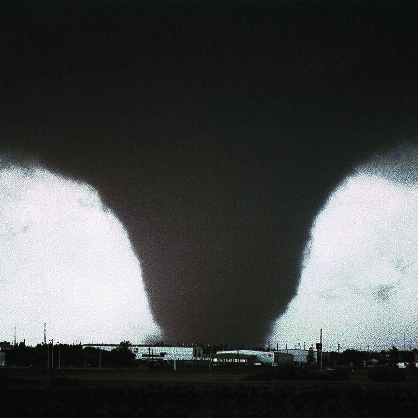
On July 31, 1987, an F4 (possibly an F5) tornado hit the eastern parts of Edmonton and Strathcona County. It left 27 dead, injured 300 and caused $332 million in damages. This is the story of Black Friday. 📸 Steve Simon 🧵 1/12

The provided photo shows the iconic image of the 1987 Edmonton tornado, captured by photographer Steve Simon. It depicts a large, wedge-shaped funnel cloud descending from a dark storm sky, touching down over an industrial area known as Refinery Row in eastern Edmonton, Alberta. The tornado appears as a bright, contrasting formation against the blackened background, with buildings, utility poles, and structures visible in the foreground.
jul 31, 2025, 12:01 pm • 86 34

Replies

avatar
Loulund🇨🇦 @loulund.bsky.social

I witnessed it..it was NUTS.

jul 31, 2025, 12:21 pm • 5 0 • view
avatar
J Youngward🇨🇦 @volodiscere.bsky.social

We were flying back from the UK that day into Calgary, the pilot came on & said we had to adjust course to go around some “bad weather”. We found out what actually happened when we landed.

jul 31, 2025, 1:42 pm • 5 0 • view
avatar
Chris Evans 🇨🇦 @chrisbal.bsky.social

I was on a Canadian Forces flight that just about landed in the thick of it. We were on approach and I could see this black black cloud and was thinking, holy sh*t are we going to land in this? At the last minute we pulled up and went to Cold Lake and heard what happened.

jul 31, 2025, 4:47 pm • 5 0 • view
avatar
Loulund🇨🇦 @loulund.bsky.social

Jezus!!

jul 31, 2025, 8:45 pm • 1 0 • view
avatar
J Youngward🇨🇦 @volodiscere.bsky.social

Trying to land at Namao?

jul 31, 2025, 9:38 pm • 0 0 • view
avatar
Chris Evans 🇨🇦 @chrisbal.bsky.social

That was the plan.

aug 1, 2025, 12:43 am • 2 0 • view
avatar
Loulund🇨🇦 @loulund.bsky.social

“Bad weather” yeeeeesh. When we were driving from Yeg to Sherwood park afterwards, it looked like the tornado picked up one of those massive storage tanks, punched it on the side and tossed it on the highway. Again, NUTS!

jul 31, 2025, 3:07 pm • 2 0 • view
avatar
Loulund🇨🇦 @loulund.bsky.social

(Oil refinery tanks)

jul 31, 2025, 3:08 pm • 0 0 • view
avatar
J Youngward🇨🇦 @volodiscere.bsky.social

We lived in the Beverley area of Clareview years later, & looking towards Sherwood Park you could still see some of the damage.

jul 31, 2025, 4:14 pm • 2 0 • view
avatar
Union Bay Portal 🇨🇦 #shipbreaking @73islander.bsky.social

Was working on the 21 st floor of the Sun Life Building that day. Terrible loss of lives.

jul 31, 2025, 10:54 pm • 2 0 • view
avatar
Neil T @biliousbarnacle.bsky.social

Rural Alberta Advantage wrote a really fantastic song about it.

jul 31, 2025, 12:16 pm • 3 0 • view
avatar
Canadian History Ehx @cdnhistoryehx.bsky.social

For a week prior to July 31, a low pressure system in southwestern BC was feeding warm and humid air into central Alberta. Hot weather in Alberta was triggering thunderstorms all week. Then, on July 31, a cold front developed in Western Alberta. 📸 Peter Cutler 🧵 2/12

The photo depicts the 1987 Edmonton tornado as a large, wedge-shaped funnel cloud, brightly illuminated against a dark stormy sky, descending and touching down over an industrial area with buildings, warehouses, and cylindrical storage tanks visible below. The image has a grainy texture typical of 1980s film photography.
jul 31, 2025, 12:01 pm • 11 0 • view
avatar
Canadian History Ehx @cdnhistoryehx.bsky.social

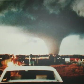
This cold front collided with the warm moist air, creating a recipe for severe thunderstorms. One storm developed that began to move northeast towards Leduc, south of Edmonton. At 2:59, the first tornado was spotted. 🧵 3/12

The photo shows a narrow, rope-like tornado funnel descending from dark, ominous clouds and touching down across a multi-lane highway, where vehicles with headlights on are visible amid reduced visibility. Trees and bushes appear in the foreground, suggesting the viewpoint is from an elevated or nearby area.
jul 31, 2025, 12:01 pm • 13 0 • view
avatar
Canadian History Ehx @cdnhistoryehx.bsky.social

That tornado briefly touched the ground and then dissipated. A second tornado touched down nearby in the Beaumont area. It destroyed several granaries and began to grow in strength. At 3:04 p.m., a tornado warning was issued for Edmonton. 🧵 4/12

The photo depicts a massive, dark wedge-shaped tornado funnel extending from turbulent storm clouds to the ground, over a distant urban or suburban landscape with buildings and structures visible under a darkened sky. In the foreground, the roof of a white car is seen on a road or highway, with open grassy areas nearby.
jul 31, 2025, 12:01 pm • 11 0 • view
avatar
Canadian History Ehx @cdnhistoryehx.bsky.social

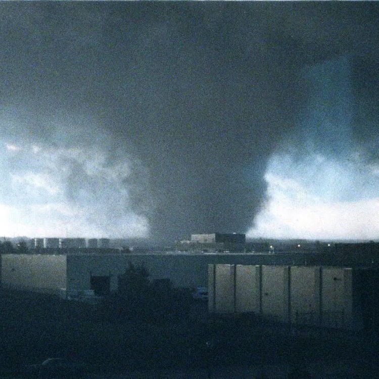
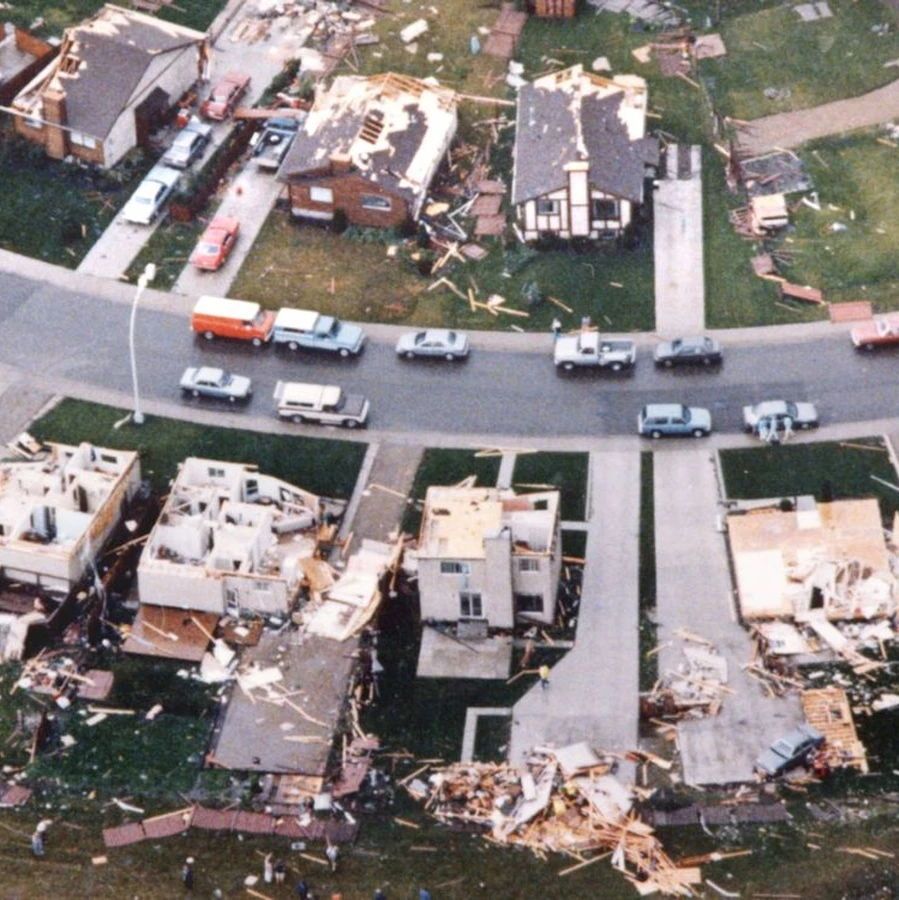
The tornado moved into the southeastern portion of the city as a multiple-vortex tornado. As it moved through the Mill Woods neighbourhood, it grew from an F2 into an F3. It then continued across the Sherwood Park Freeway into Refinery Row. 📸 Tom Braid 🧵 5/12

The photo depicts a large white cylindrical storage tank numbered
jul 31, 2025, 12:01 pm • 11 0 • view
avatar
Canadian History Ehx @cdnhistoryehx.bsky.social

By this point, it was an F4. The tornado tossed around oil tanks, destroyed various buildings and threw work trailers around. It is believed at this point, the tornado was a borderline F5 but this has not been confirmed. 🧵 6/12

The photo is an aerial view of extensive destruction at an industrial site, showing a large warehouse-like building with its roof completely collapsed, exposing twisted metal beams, wooden debris, and rubble piled high. A beige office section remains partially standing with broken windows and a sign possibly reading
jul 31, 2025, 12:01 pm • 10 0 • view
avatar
Canadian History Ehx @cdnhistoryehx.bsky.social

As the tornado moved over the North Saskatchewan River, it became an F2/F3. It then hit the Clareview area, followed by neighbourhoods in northeast Edmonton. Along with that tornado, another seven tornadoes were reported in the area. 🧵 7/12

The photo is an aerial view of the Sherwood Park Freeway in Edmonton, Alberta, showing heavy traffic congestion on the multi-lane highway post-disaster. Extensive destruction is visible on both sides, including demolished industrial buildings, scattered debris fields, overturned vehicles and heavy equipment, and ravaged grassy areas adjacent to the road.
jul 31, 2025, 12:01 pm • 11 0 • view
avatar
Canadian History Ehx @cdnhistoryehx.bsky.social

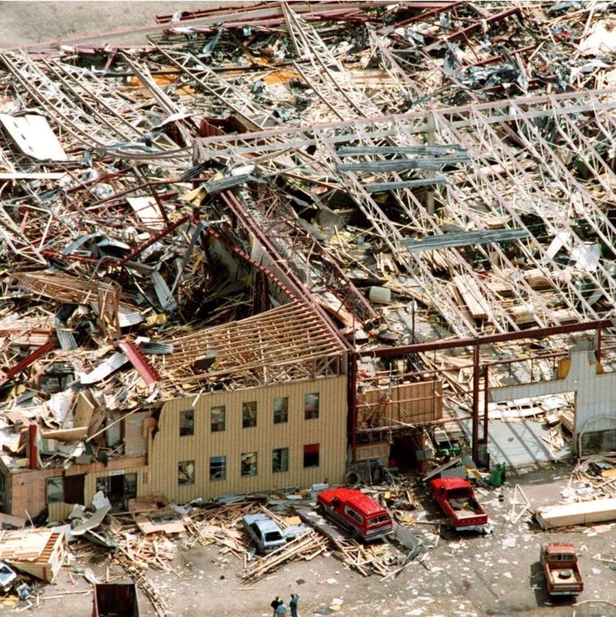
There was one F4, two F2s, an F1 and four F0s. Another F2 touched down south of Edmonton in Millet, as well as one near Vegreville. The Vegreville tornado caused $40,000 in damages and was on the ground for 52 kilometres. 📸 Tom Braid 🧵 8/12

The photo shows three firefighters in yellow helmets and black turnout gear with reflective stripes conducting a search and rescue operation amid a vast field of debris, including splintered wood, twisted metal, insulation, and household items. One firefighter crawls under an overturned dark blue sedan perched sideways on the rubble pile, while another climbs on the car's undercarriage, and a third stands nearby. The background reveals widespread devastation, with flattened structures and trailers extending to the horizon under a cloudy sky.
jul 31, 2025, 12:01 pm • 11 0 • view
avatar
Canadian History Ehx @cdnhistoryehx.bsky.social

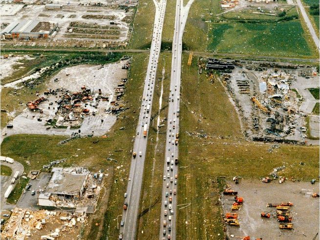
The F4 that hit Edmonton killed 27 people, making it the second-deadliest tornado in Canadian history after the 1912 Regina Cyclone. It injured 300 people and caused over $330 million in damages ($800 million today). The tornado led to major changes in weather reporting. 🧵 9/12

The photo is an aerial view of a suburban residential neighborhood showing varying degrees of tornado damage: several mobile homes and houses at the bottom are completely demolished, reduced to foundations with debris piles of wood, insulation, and rubble scattered across yards; upper houses have roofs partially or fully stripped, with vehicles parked along the curving street and a few people visible amid the wreckage on grassy lots.
jul 31, 2025, 12:01 pm • 12 0 • view
avatar
Canadian History Ehx @cdnhistoryehx.bsky.social

The Emergency Public Warning System, now the Alberta Emergency Alert, was developed after the disaster. The warning system breaks into all broadcasts on radio and television, as well as on cellular phones now. It is also used for Amber Alerts. 🧵 10/12

The photo is a simplified map of Edmonton, Alberta, and environs, depicting the path of the 1987 tornado as a thick black line traversing from southwest to northeast. The track begins near Mill Woods (labeled F2), curves through the city along the North Saskatchewan River (shown in blue), intensifies to F4 near Sherwood Park, then proceeds to F2 near the city center (point O), F2 at point C, F2/F3 at point P, and ends near Evergreen with F2/F3. Major highways like 2, 216, 16, 16A, 14, 15, 21, and 28 are marked in orange and yellow, with suburban areas shaded in beige.
jul 31, 2025, 12:01 pm • 10 0 • view
avatar
Canadian History Ehx @cdnhistoryehx.bsky.social

In 1987, there were only three Doppler radars in operation in Canada, including one near Edmonton. The disaster led to the wide adoption of Doppler radars in Canada. Learn more in my Deep Dive 👇 canadaehx.com/2023/07/25/t... 🧵 11/12

jul 31, 2025, 12:01 pm • 13 1 • view
avatar
brickbq.bsky.social @brickbq.bsky.social

Project 25 ... get rid of 25% of traffic lights in Edmonton. Take a look at Palm Springs .. shopping center traffic is directed to one exit. And I love the playground speed limits ... when Children are Present.

aug 3, 2025, 4:43 am • 0 0 • view
avatar
Andrew Iwaniuk @evoneuro.bsky.social

I saw one of the twisters from a distance and remember listening to the radio with my mum and siblings in the basement for close to an hour waiting for updates. My dad was working at the UofA hospital and it was the only time in his career they called a Code Orange (mass casualties)

jul 31, 2025, 1:45 pm • 1 0 • view