
Jeff Berardelli
@weatherprof.bsky.social
Same @WeatherProf as Twitter. Posting about climate and weather. Chief Meteorologist and Climate Specialist WFLA NBC Tampa
created September 29, 2023
22,392 followers 986 following 708 posts
view profile on Bluesky Posts
 Jeff Berardelli (@weatherprof.bsky.social)
Meteorological summer is now in the books. It was the 3rd hottest in Tampa's history. Tampa International Airport hit two major milestones in 2025. First 100 degree day on record and the hottest heat index on record (119)! Both all-time highs at the end of July.
 Jeff Berardelli (@weatherprof.bsky.social)
Monday 2pm: Chances for development are rising in the East Atlantic. Now medium, 50% chance. Below are the latest Google AI ensemble members spaghetti tracks. Worth watching - most likely will get recurved out to sea - but that’s not set in stone. Plenty of time to watch.
 Jeff Berardelli (@weatherprof.bsky.social) reply parent
No Dice on the cold for you Florida, but this extreme jet will at least act as a tropical trouble blocker - like a wall - for at least the next 10 days. Temps will reach 35 degrees plus and minus normal in the west and east respectively.
 Jeff Berardelli (@weatherprof.bsky.social)
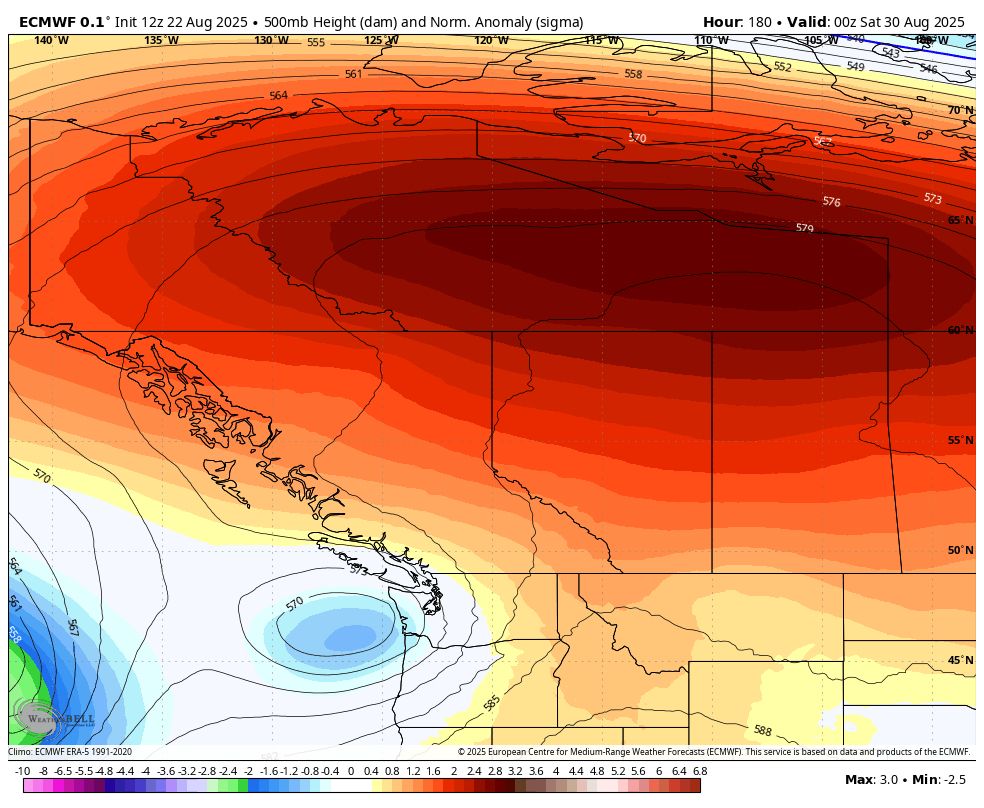
Get ready for a WILD ride across the US this week! Extreme jet stream means extreme heat in the West, and very early cold in the East! 105+ in the Pacific NW, 30s in the Great Lakes and Upper Midwest, and a real taste of Autumn in the East. 1/
 Jeff Berardelli (@weatherprof.bsky.social)
#Katrina set the record for the highest US surge at ~28 feet. But the world record is an astonishing 43 ft from Cyclone Mahina in Queensland Australia in 1899.
 Jeff Berardelli (@weatherprof.bsky.social) reply parent
An incredibly destructive 28 ft of surge was the max, a record for the US.
 Jeff Berardelli (@weatherprof.bsky.social) reply parent
It jumped from cat 2 to cat 5 (175 mph) over the hot current. What made Katrina so devastating was the surge, which was made worse by several factors: huge sized storm, intense, slow moving, plowing into a very shallow water, into a geographical coastline which funnels / focuses water in and up. 2/
 Jeff Berardelli (@weatherprof.bsky.social)
20 years ago today #Katrina changed lives forever. Over the Gulf it was a cat 5 behemoth bulldozing a wall of water onshore. Part of its power came from the Gulf Loop Current, an ever present feed of deep hot Caribbean water. 1/
 Jeff Berardelli (@weatherprof.bsky.social) reply parent
Here’s Tampa
 Jeff Berardelli (@weatherprof.bsky.social) reply parent
Warming on global and regional levels is driven by greenhouse warming from the greenhouse gases and on a local level also from urbanization.
 Jeff Berardelli (@weatherprof.bsky.social)
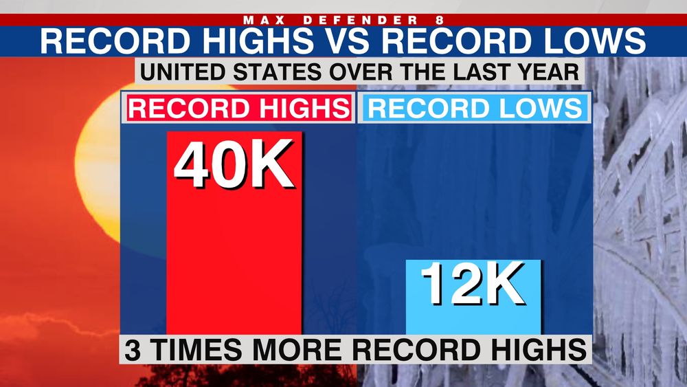
Record heat now outnumbers record cold by more than 3 to 1 in the US. In a normal climate, they’d be equal. After billions of years of natural hot & cold cycles, human forcing has now overtaken nature as the longterm driving force of our present & future climate.
 Jeff Berardelli (@weatherprof.bsky.social)
An early season cold front resulted in over 100 record lows across the Ohio & TN Valley. This is a very rare feat now-a-days - due to climate change warming. When you look at the past year in the US record highs outnumber record lows by more than 3 to 1. Here's more in the Berardelli Bonus...
 Jeff Berardelli (@weatherprof.bsky.social)
Listen closely you can hear a pin drop in the Atlantic. But on average 75% of Atlantic tropical activity is ahead. Being this quiet is rare as we approach peak season (last Aug was dead). Right now background climate state is unfavorable for development, but that will likely change by mid Sept
 Jeff Berardelli (@weatherprof.bsky.social)
A chill in the air today! (Not you FL) Over 100 record lows tied or broken Wednesday in the eastern US. That’s extremely rare now-a-days in our warmer climate changed World. Over the past year, record warm temps outnumber record cold temps 3 to 1 in the US. Animation via CoolWx
 Jeff Berardelli (@weatherprof.bsky.social)
In life - they say - there are the Haves and the Have nots. Which of you were lucky enough to Have the dry air today? And which of you are angry at the weatherman?
 Jeff Berardelli (@weatherprof.bsky.social) reply parent
@rarohde.bsky.social mentioned the answer a few days ago. Robert… did you say something like 85% upwelling?
 Jeff Berardelli (@weatherprof.bsky.social)
Would like to see this used alongside other methods in climate attribution studies once it is ready for primetime... phys.org/news/2025-08...
 Jeff Berardelli (@weatherprof.bsky.social)
False fall is in the air! Numerous record lows possible in the Ohio and TN Valley area with spots up to 20 degrees below normal.
 Jeff Berardelli (@weatherprof.bsky.social)
Waterlogged? You are not the only one. It's been a super soggy August so far, especially the past week. Sarasota is almost 5" above normal! Droughtbusting for many. We get a break the next couple of days with less rain and lower humidity north of Tampa Bay. The rain ramps back up this weekend.
 Jeff Berardelli (@weatherprof.bsky.social)
Massive cool corridor still visible after #Erin churned up the seas with 50+ ft waves. #hurricane Cooler water caused by upwelling and heat used to power engine.
 Jeff Berardelli (@weatherprof.bsky.social)
A long-major heatwave is setting up for Central & NW Canada with temperatures 15-20 degrees C (30F plus) warmer than normal late next week into next weekend. That means widespread 30-35C high temps (85-95F) way up north even near the Tundra. Climate change has made these events more intense/ likely
 Jeff Berardelli (@weatherprof.bsky.social)
Florida be like: “REALLY!?!?” (These are departures from normal coming up this week. Blue & green is below normal.) Figures.
 Jeff Berardelli (@weatherprof.bsky.social)
Outlandishly amplified jet stream for August. Widespread 50s for morning lows in Midwest, Ohio Valley & Northeast. Taste of false fall! Even some relief in the deep south! Nope, not you Florida. Meanwhile in NW Canada a big heat dome w/ temps 30F + above normal, highs in the 90s near the Tundra.
 Jeff Berardelli (@weatherprof.bsky.social)
Not all Hurricanes are created equal. (Cat 2?) #HurricaneErin tomorrow vs (Cat 2?) #90L in a few days. Remarkable size difference.
 Jeff Berardelli (@weatherprof.bsky.social) reply parent
Worth mentioning that much of the cooling of the surface water is due to turbulent mixing and upwelling of cool waters from below.
 Jeff Berardelli (@weatherprof.bsky.social)
Look at the sea surface temps in Erin’s wake - dropped 5 degrees F!! As a result of all the heat energy Erin burned, it’s accumulated cyclone energy (ACE) is already at 30 Units, headed for 36+, likely beating the total energy of the entire 2013 hurricane season! Happy to say goodbye now to Erin.
 Jeff Berardelli (@weatherprof.bsky.social) reply parent
Yes I was about to check to see if there was indeed an inversion at 7pm when I realized the ballon was at 8 :(
 Jeff Berardelli (@weatherprof.bsky.social) reply parent
Thank you :) I make the graphics
 Jeff Berardelli (@weatherprof.bsky.social) reply parent
Not 100% sure but it was a west wind so it may have been dragged in from the bay
 Jeff Berardelli (@weatherprof.bsky.social) reply parent
… allowing its pressure to drop, winds to increase, and wind field to expand into an enormous storm.
 Jeff Berardelli (@weatherprof.bsky.social)
Science!! Why did #erin strengthen again? Tuesday strong winds aloft chopped Erin’s head off. But Erin fought back! Expanding its circulation & outflow, by powering itself with the hottest, high-octane water yet, it shoved the wind shear aside, building a protective cocoon overhead 1/
 Jeff Berardelli (@weatherprof.bsky.social)
#Erin is a behemoth. We are lucky it’s not making landfall! It’s intensifying fast and growing in size. The pressure dropped 18mb, from 959 to 941 mb since last night. The wind field is massive. Last night’s video below explains the various factors leading to this rejuvenation.
 Jeff Berardelli (@weatherprof.bsky.social)
Erin looks like a shrimp! That’s sometimes a tell-tale sign that a storm is about to intensify! Nope. I’m not kidding. Conditions are improving for Erin to strengthen. Here’s what’s going on! #erin #hurricane #HurricaneErin
 Jeff Berardelli (@weatherprof.bsky.social) reply parent
It’s moving. Just not fast. It will pick up the pace soon! But yes it’s been going on for days!
 Jeff Berardelli (@weatherprof.bsky.social)
#erin is a creeper! The track has crept ~450 miles further west than the model consensus since the Storm developed. Still not a bad forecast for a storm that has traveled ~3500 miles. Still the size/ intensity of Erin will bring significant impacts to coastal NC. Image via Tomer Burg
 Jeff Berardelli (@weatherprof.bsky.social)
Hurricane Erin will not be a direct hit, but uncomfortably close, closer than the model consensus. Our high res GRAF model shows Hurricane force wind gusts scraping up against the Outer Banks coast, with 20+ ft waves near shore. The gusts in light gray are 130 mph plus. #hurricane #erin
 Jeff Berardelli (@weatherprof.bsky.social)
Did you know hurricanes are two-faced? While the circulation of the behemoth #Erin is comprised of rapidly rising/ rotating air, on the outside the opposite is true. Air sinks & crushes the clouds, making for calm, sunny weather far away from the storm. Some of Florida will experience that Midweek.
 Jeff Berardelli (@weatherprof.bsky.social) reply parent
Now, worth mentioning you need a whole lot more than hot water for a cat 5 & RI - all factors must line up - but if they do, hotter than normal water makes it much more possible. Thanks to Climate Central for the GFX!
 Jeff Berardelli (@weatherprof.bsky.social) reply parent
That means that a storm - which in the 1980s - had a RI of 40 mph in 24 hours, would likely have an RI of 60 mph in 24 hours now (on average). That makes storms much more destructive (if they landfall of course). It’s not coincidence, it’s climate change! 5/
 Jeff Berardelli (@weatherprof.bsky.social) reply parent
RI has increased by almost 5 mph per decade over the past 40 years. That means that a storm - which in the 1980s - had a RI of 40 mph in 24 hours, would likely have an RI of 60 mph in 24 hours now (on average). 4/
 Jeff Berardelli (@weatherprof.bsky.social) reply parent
The image shows water in the vicinity of the Rapid Intensification (RI) was almost 2F above normal, hot waters made much more likely by climate change. Studies show episodes of Rapid Intensification (esp. extreme RI) have increased significantly over the past few decades as waters have warmed 3/
 Jeff Berardelli (@weatherprof.bsky.social) reply parent
Also, there was a 78 mb drop in 24 hours, a feat only achieved by 2 other storms since 1980, and those were both in October (Milton & Wilma). Erin was the 5th earliest cat 5 on record. 2/
 Jeff Berardelli (@weatherprof.bsky.social)
Hurricane Erin achieved something most storms do not this weekend. "Extreme Rapid Intensification". Did climate change play a part? Science says, yes. In 12 hours winds increased by ~65 mph. Only 3 other storms have done that and Erin was the earliest & only August storm to do so. 1/
 Jeff Berardelli (@weatherprof.bsky.social) reply parent
lol “rogue” wave not “rouge” like the color Although I imagine there are rouge waves :)
 Jeff Berardelli (@weatherprof.bsky.social) reply parent
…typically there are rouge waves much larger, and indeed the models forecast maximum wave heights around 100 ft. Will it happen. Yes, probably when it gets north in its extratropical transition. Will we get a record of it? Not likely. Buoys are sparse along the track.
 Jeff Berardelli (@weatherprof.bsky.social) reply parent
… in 2019, likely the “reliable”record for largest wave, but there have been many “reports” of waves nearly that big or bigger. Erin’s significant wave height (pictured here) is forecast to be 60 ft. That means most waves will be in that range near the core. But… 2/
 Jeff Berardelli (@weatherprof.bsky.social)
100 ft wave!? Not out of the question for #erin I see folks posting “maximum” wave heights - likely for clicks - but the right metric is significant wave height because the 100 ft waves will be rouge not common. Now, Hurricane Dorian did cause a rouge wave off New Foundland measured at 100ft 1/
 Jeff Berardelli (@weatherprof.bsky.social)
Major Hurricane #Erin is intense, but soon it will be massive in size. As the storm moves north the wind field will expand. Tropical storm force gusts will extend all the way from the beaches of the Eastern Seaboard to Bermuda around 700 miles, with hurricane gusts over 300 miles wide. #hurricane
 Jeff Berardelli (@weatherprof.bsky.social) reply parent
The water cools not just due to heat absorption, but also overturning / upwelling, wind and rain.
 Jeff Berardelli (@weatherprof.bsky.social)
#Hurricaneerin is hungry. It will feast on hot water up to 88 degrees. After using this heat to power its engine, it will dissipate said heat. Leaving a cool ocean wake in its path, ~10 degrees lower than it found it. #erin
 Jeff Berardelli (@weatherprof.bsky.social)
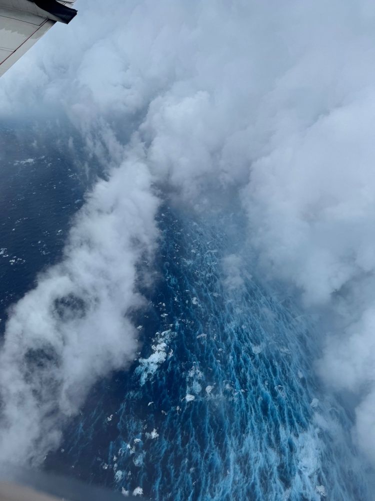
Look closely!! Taken today from NOAA Hurricane Hunters on tne edge of an intense eyewall in Hurricane #Erin… See how the ocean surface calm inside the eye but turbulent & rough in the eyewall!
 Jeff Berardelli (@weatherprof.bsky.social) reply parent
Well produces is prob not technically right… expends / dissipates etc
 Jeff Berardelli (@weatherprof.bsky.social)
#Erin now a Cat 5 with 160 mph winds! And it’s moving south/ west of the forecast cone as it seems to be dictating its own terms right now. Hopefully it will make a turn NW soon. At the end of the loop you can see the NW jog. The beginning of the trend NW? #hurricaneerin
 Jeff Berardelli (@weatherprof.bsky.social)
#Erin intensified from a Tropical Storm to a Cat 4 in 24 hours… Talk about rapid intensification! 75 mph jump! Over the past few decades RI has increased a few mph each decade so storms now can intensify an extra 20+ mph more in the same time frame, likely due to warming waters. #HurricaneErin
 Jeff Berardelli (@weatherprof.bsky.social)
#erin now a Cat 4/ 145 mph will become so large, so intense and so long lived it may burn through more energy than the entire 2013 season! But what is the purpose of Hurricanes in Mother Nature’s elegant design? They redistribute a lot of heat! We discuss… #hurricane #hurricaneerin #stem #climate
 Jeff Berardelli (@weatherprof.bsky.social)
As long as #hurricaneerin behaves, it's evolving into a best case scenario, esp for weather geeks. Textbook major hurricane (145mph) that does not strike land. What stands out is NHC forecasts Erin a cat 4 Sunday-Wednesday. This storm is going to be a prolific ACE Accumulated Cyclone Energy producer
 Jeff Berardelli (@weatherprof.bsky.social)
The summer swelter is back! Yet another heat dome. 113 today in Tampa, FL for the heat index! Same heat tomorrow. Since 1930s Tampa has only had a couple of dozen, if that, heat index days above 113. A warming climate makes these intense heat domes (and oppressive heat) more likely and more intense
 Jeff Berardelli (@weatherprof.bsky.social)
I hereby grant everyone a 3 day weekend. Take the day off and stay inside. There. Solved it! Heat Advisory in effect today. Stay cool.
 Jeff Berardelli (@weatherprof.bsky.social)
New At 11: #Erin still a Tropical Storm but now forecast to become a category 4.
 Jeff Berardelli (@weatherprof.bsky.social)
Luckily #erin looks like it will miss the East Coast, hopefully right through the uprights. Because it will be a monster!!
 Jeff Berardelli (@weatherprof.bsky.social)
#Erin has labored due to cool water and dry air. But it’s about to encounter high octane fuel and go through explosive intensification. I explain in today’s Berardelli Bonus
 Jeff Berardelli (@weatherprof.bsky.social)
“Here we show that the main multidecadal variations in the PDO index during the twentieth century, including the ongoing, decades-long negative trend, were largely driven by human emissions of aerosols and greenhouse gases rather than internal processes.” www.nature.com/articles/s41...
 Jeff Berardelli (@weatherprof.bsky.social)
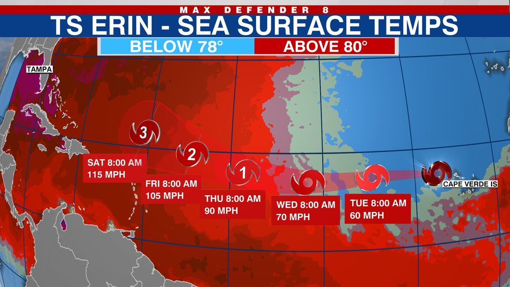
It’s going to be a big few days for #Erin. Water temps in the darkest shade of red, which happen to be right under its path, are near or at record hot. Assuming it sheds most of its dry air, Cat 4 should not be difficult to achieve.
 Jeff Berardelli (@weatherprof.bsky.social)
As is typical this far out, there’s a decent spread in model solutions for #Erin, with the Euro furthest west just off the NC coast, to the GFS furthest east near Bermuda. This is valid one week from today (Wednesday)
 Jeff Berardelli (@weatherprof.bsky.social)
The exact path of #Erin is still not set in stone. But with a major Cat 3/4 and expanding wind field as it moves north, there will be some huge waves near the path. Likely some 50 ft waves near the core, rough surf & dangerous rip currents up & down the coast from FL to the Carolinas and New England
 Jeff Berardelli (@weatherprof.bsky.social)
11am NHC track. Steady as she goes…
 Jeff Berardelli (@weatherprof.bsky.social)
Good news on #Erin in the latest runs. ALL Euro ensembles miss the US. This is very good agreement and an improvement from yesterday. The break in the ridge/ escape route is large and Erin seems like it will take the bait. Stay tuned…
 Jeff Berardelli (@weatherprof.bsky.social)
Erin has been over cool water the past 2 days. That changes Wednesday. By the weekend / early next week it will encounter much hotter water (near record levels) and #Erin is likely to become a major category 3 or 4.
 Jeff Berardelli (@weatherprof.bsky.social)
Communicating the climate challenge has been a - challenge - to say the least. Branding a simple, repetitive message is necessary David fenton - long time branding/ climate pro says says "the pollution blanket" conjurs simple visual of climate pollution heating us www.theframelab.org/how-a-simple...
 Jeff Berardelli (@weatherprof.bsky.social) reply parent
Hi Richard. Hope all is well with you. It's Google Deep Mind WeatherLab deepmind.google.com/science/weat...
 Jeff Berardelli (@weatherprof.bsky.social)
Along the US East Coast? There's reason for optimism. The latest #Erin trend - past 4 runs show a consistent east trend. With that said, w/ a weak #Erin now expect more windshield wiper action w/ models waffling until the storm is better developed. Bottom line: cautious optimism but not certainty.
 Jeff Berardelli (@weatherprof.bsky.social)
#Erin looks weak and ragged today for2 reasons. 1. Cool oceans temps at critical 78 F threshold. 2. Lots of saharan dust & dry stable air. In 24-48 hours it will move across much warmer water and the dust will disperse some. That will support sustainable convection and allow for intensification.
 Jeff Berardelli (@weatherprof.bsky.social)
Due to AI there are more tools in the toolbox this year. Here is the new Google AI model. Shows most members (and average track) recurving #erin. But a few members much closer to FL and the Bahamas. The trend from most models over the past day has been slightky further south and west. Stay tuned.
 Jeff Berardelli (@weatherprof.bsky.social) reply parent
…how far north will Erin be and will it be able to take early enough advantage of it, to miss the Eastern Seaboard? Odds are yes. But the latest guidance is not as clear cut. The latest models have shifted significantly southwest, opening the door to a closer call. Stay tuned!
 Jeff Berardelli (@weatherprof.bsky.social)
Where will #Erin track? It’s being steered by an elongated, but not very strong, ridge of high pressure. By the weekend that ridge will break, allowing for a weakness / escape alley to develop. The question is… 1/
 Jeff Berardelli (@weatherprof.bsky.social)
#erin developed on north side of Cape Verde Is in marginally warm water. Critical threshold for TS formation is ~78F+. In the next 1-2 days Erin will be over mild water so development will be limited. But by mid-late week water warms and Erin will be off to the races. Major hurricane likely.
 Jeff Berardelli (@weatherprof.bsky.social) reply parent
It can and may happen, so we’ll continue to watch, but no need for alarm. WFLA News Channel 8 @topfans Great graphic by FSU
 Jeff Berardelli (@weatherprof.bsky.social)
Putting aside the current atmospheric steering… What are the chances a storm like #erin hits the US starting from its current position (red TS symbol on bottom right) on the north side of the Cape Verde Islands? Answer: Low (purple) less than 10%, based on historical probabilities. So it’s rare 1/
 Jeff Berardelli (@weatherprof.bsky.social)
#erin is developing over relatively cool water. That will change as the storm moves west into much warmer water, allowing for strengthening. Major hurricane forecast. Image: CyclonicWx
 Jeff Berardelli (@weatherprof.bsky.social)
#Erin is born. Forecast to become at major hurricane north of the Lesser Antilles by the weekend.
 Jeff Berardelli (@weatherprof.bsky.social) reply parent
For good measure, here’s the tool and chart with numbers.
 Jeff Berardelli (@weatherprof.bsky.social) reply parent
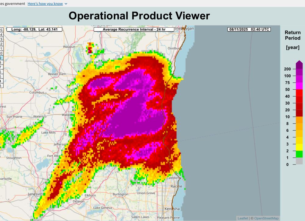
Follow the top line (black) that’s the 1-in-1000 recurrence interval. In 24 hours it’s 10” In 10 days it’s 14 inches. 2/
 Jeff Berardelli (@weatherprof.bsky.social)
14” in a day is easily a 1-in-1000 year event for Milwaukee. It’s insane this far north. Actually 14” in 10 days meets the 1-in-1000 year criteria. Yes, read that again. To be clear, this doesn’t mean it only happens once every 1000 years, it means the chance in any one year is .1% More below 1/
 Jeff Berardelli (@weatherprof.bsky.social)
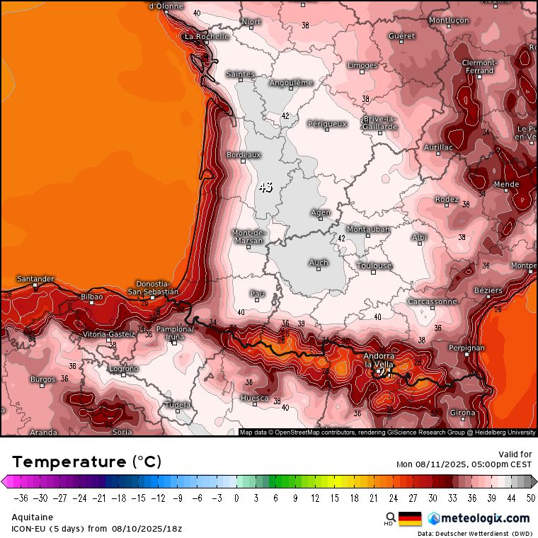
Could hit 110F (43-44C) on Monday from near Toulouse to near Bordeaux France. 🇫🇷 All-time record time is 46C (~115F) This can’t be ideal for 🍷 or any crops for that matter.
 Jeff Berardelli (@weatherprof.bsky.social)
For Sanibel Island, FL, 11” in 12 hours is a ~ 1-200 year recurrence interval. A rare event in our past, made more common by a warmer climate.
 Jeff Berardelli (@weatherprof.bsky.social)
arstechnica.com/science/2025...
 Jeff Berardelli (@weatherprof.bsky.social)
The African wave getting all the fanfare has now been outlooked by NHC at an initial 20% chance of development.
 Jeff Berardelli (@weatherprof.bsky.social)
The Atlantic Wave Train is about to leave the station!! By late next week we’ll be tracking multiple African waves moving across the Atlantic. Question is, do they develop and where do they track? Don’t put much stock into the details on the image…it’s meant to illustrate the Atlantic coming alive.
 Jeff Berardelli (@weatherprof.bsky.social)
Not an easy feat today with all the storms, but Tampa hit 98, breaking the daily record. It did this before the storms moved in at 12:47 pm. We don't get to 98 very often at TPA.
 Jeff Berardelli (@weatherprof.bsky.social) reply parent
That's because it's almost 2 weeks away IF it heads this way. The map shows the X where the wave is now and the number of days it takes, on average, to reach the US from there. Clearly it's far into the 10+. Bottom line: We wait, we watch, but we don't worry.
 Jeff Berardelli (@weatherprof.bsky.social)
A lot has been posted about the tropical wave about to move off Africa. There are a lot of IF's like: IF it will develop. IF it will move towards the US etc... Models are aggressive with development BUT it is too early to know. With that said, we have plenty of time to watch it. 1/
 Jeff Berardelli (@weatherprof.bsky.social)
Rain totals though Sunday could be several inches in spots! Deep tropical moisture is moving in and will be with us through the weekend. Sunny starts and stormy ends Friday and Saturday. But Sunday may turn out to be stormy much of the day.
 Andrew Freedman (@afreedma.bsky.social) reposted
Energy Secretary Chris Wright says Trump admin is altering previous National Climate Assessments. These were produced by hundreds of climate scientists and mandated by Congress. (1/2)
 Jeff Berardelli (@weatherprof.bsky.social)
There's a ton of "stuff" floating out here on the inner webs regarding the tropics. Most is nonsense and clickbait. One thing is true: things are starting to wake up, as they typically do in August. Below you are looking at are the European model ensembles "pressure centers" over the next 15 days.
 Jeff Berardelli (@weatherprof.bsky.social) reply parent
Compare that to the average flash length of ~5 miles (it varies). FYI… The longest duration strike was 17 seconds in Argentina. Lightning is 50,000 degrees, 5X the temperature of the surface of the Sun!
 Jeff Berardelli (@weatherprof.bsky.social)
Imagine a lightning flash from Miami to Pensacola!?! Impossible right? Nope! A few days ago the World Meteorological Organization (WMO) certified a 515 mile lightning flash! It spanned from Kansas City to Dallas in 2017. A new World record! 1/
 Jeff Berardelli (@weatherprof.bsky.social)
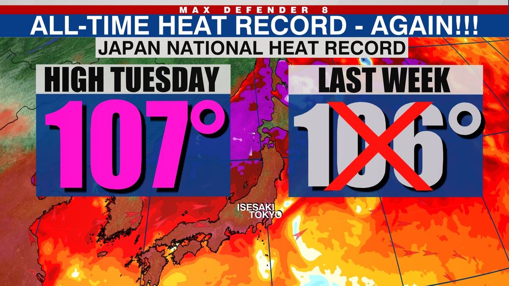
On Japan’s 2nd All-time National heat record in a week. While these records are more likely now due to climate change, it’s worth looking at the details. Extreme marine heat wave. West wind downslopes off mountains into valley town of Isesaki (where it hit 107) and heats due to drying/compression.
 Jeff Berardelli (@weatherprof.bsky.social) reply parent
A strong heat ridge to the south is now giving way to a deep trough with gusty winds ahead of it. Nestled in-between mountains, a downslope wind likely amplified the heat through compressional heating. I'll follow up later with an animation.
 Jeff Berardelli (@weatherprof.bsky.social)
Japan broke it's All-time NATIONAL heat record for the 2nd time in... checks notes... less than a week! It's not coincidence. It's climate change. Japan is surrounded by the most anomalously hot water on the planet right now. The city of Isesaki hit 107 - it's in a valley NW of Tokyo. 1/
 Jeff Berardelli (@weatherprof.bsky.social)
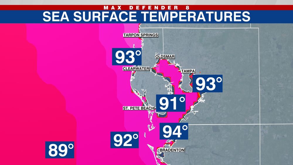
Need some relief from the heat Tampa Bay? Take a dip into the refreshi... Never mind. The Gulf is en fuego!
Jeff Berardelli (@weatherprof.bsky.social)


